Arilje geodata
Arilje (Central Serbia) is a seat of a third-order administrative division; located in Serbia in Europe/Belgrade (GMT+2) time zone. With population of 6,762 people, there are 70 cities with bigger population in this country. Compared to other cities in Serbia, 83.2% of cities are located further ↑North; 63.3% of cities are located further →East and 87.3% of cities have lower elevation than Arilje. Note1


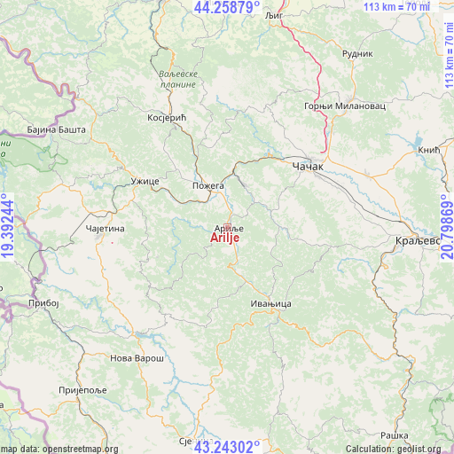
Arilje GPS coordinates[2]
43° 45' 11.016" North, 20° 5' 44.016" East
| Map corner | latitude | longitude |
|---|---|---|
| Upper-left | 44.25879°, | 19.39244° |
| Center: | 43.75306°, | 20.09556° |
| Lower-right: | 43.24302°, | 20.79869° |
| Map W x H: | 112.9×112.9 km | = 70.2×70.2mi |
| max Lat: | 46.1° ⇑83.2% North |
| Arilje: | 43.75306° |
| min Lat: | ⇓16.8% South 42.25846° |
| min Long | Arilje | max Long |
| 18.9276° | 20.09556° | 22.77556° |
| W 36.7%⇐ | ⇒63.3% E |
Elevation
Elevation of Arilje is 334 m = 1096 ft, and this is 157.6 m = 517 ft above average elevation for this country.
| Max E: |
1421 m = 4662 ft | 12.7% |
| Arilje | 334 m 1096 ft | |
| Avg. | 176.4 m = 579 ft | |
Min E: |
49 m = 161 ft | 87.3% |
See also: Serbia elevation on elevation.city.
Geographical zone
Arilje is located in North temperate zone (between Tropic of Cancer and the Arctic Circle). Distance of this Northern Tropic circle is 2259 km =1403.7 mi to South.| Distance of | km | miles | from Arilje |
|---|---|---|---|
| North Pole | 5142.2 | 3195.2 | to North |
| Arctic Circle | 2536.3 | 1576 | to North |
| Tropic Cancer | 2259 | 1403.7 | to South |
| Equator | 4864.9 | 3022.9 | to South |


Nearby cities:
15 places around Arilje: (largest is in red/bold)
• Brezovica
25.6 km =15.9 mi,  91°
91°
• Donja Gorevnica
35.3 km =21.9 mi,  66°
66°
• Gornji Milanovac
42.2 km =26.2 mi,  44°
44°
• Ivanjica
22.1 km =13.7 mi,  150°
150°
• Kosjerić
31 km =19.3 mi,  330°
330°
• Kraljevo
47.8 km =29.7 mi, 93°
• Lučani
12.5 km =7.8 mi,  15°
15°
• Mokra Gora
48 km =29.8 mi,  274°
274°
• Nova Varoš
39.8 km =24.7 mi,  215°
215°
• Požega
11.7 km =7.3 mi,  335°
335°
• Prislonica
35.1 km =21.8 mi,  50°
50°
• Užice
23 km =14.3 mi,  300°
300°
• Zlatibor
31.9 km =19.8 mi, 265°
• Čajetina
30.8 km =19.1 mi, 269°
• Čačak
25.5 km =15.8 mi, 52°
Sources, notices
• [Note1] Compared only with cities in Serbia existing in our database
• [Src1] Map data: © OpenStreetMap contributors (CC-BY-SA)
• [Src2] Other city data from geonames.org with taken over terms of usage.
• [Src3] Geographical zone / Annual Mean Temperature by Robert A. Rohde @ Wikipedia
