Monastyrishche geodata
Monastyrishche (Primorskiy (Maritime) Kray) is a populated place; located in Russia in Asia/Vladivostok (GMT+10) time zone. With population of 4,192 people, there are 3005 cities with bigger population in this country. Compared to other cities in Russia, 90.8% of cities are located further ↑North; 95.8% of cities are located further ←West and 61% of cities have higher elevation than Monastyrishche. Note1


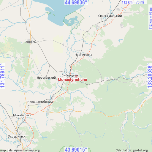
Monastyrishche GPS coordinates[2]
44° 11' 47.076" North, 132° 30' 8.028" East
| Map corner | latitude | longitude |
|---|---|---|
| Upper-left | 44.69836°, | 131.79911° |
| Center: | 44.19641°, | 132.50223° |
| Lower-right: | 43.69015°, | 133.20536° |
| Map W x H: | 112.1×112.1 km | = 69.7×69.7mi |
| max Lat: | 73.50819° ⇑90.8% North |
| Monastyrishche: | 44.19641° |
| min Lat: | ⇓9.2% South 41.28413° |
| min Long | Monastyrishche | max Long |
| -179.12198° | 132.50223° | 179.35046° |
| W 95.8%⇐ | ⇒4.2% E |
Elevation
Elevation of Monastyrishche is 122 m = 400 ft, and this is 80.6 m = 264 ft below average elevation for this country.
| Max E: |
2518 m = 8261 ft | 61% |
| Avg. | 202.6 m = 665 ft | |
| Monastyrishche | 122 m = 400 ft | |
Min E: |
-28 m = -92 ft | 39% |
See also: Russia elevation on elevation.city.
Geographical zone
Monastyrishche is located in North temperate zone (between Tropic of Cancer and the Arctic Circle). Distance of this Northern Tropic circle is 2308.3 km =1434.3 mi to South.| Distance of | km | miles | from Monastyrishche |
|---|---|---|---|
| North Pole | 5092.9 | 3164.6 | to North |
| Arctic Circle | 2487 | 1545.3 | to North |
| Tropic Cancer | 2308.3 | 1434.3 | to South |
| Equator | 4914.2 | 3053.5 | to South |


Nearby cities:
15 places around Monastyrishche: (largest is in red/bold)
• Anuchino
51.3 km =31.9 mi,  120°
120°
• Blagodatnoye
35.7 km =22.2 mi,  293°
293°
• Chernigovka
17.1 km =10.6 mi,  18°
18°
• Chernyshëvka
50.2 km =31.2 mi,  89°
89°
• Grigor’yevka
40.7 km =25.3 mi,  264°
264°
• Ivanovka
25.4 km =15.8 mi,  183°
183°
• Khorol’
42.4 km =26.3 mi,  307°
307°
• Luchki
21.7 km =13.5 mi,  297°
297°
• Lyalichi
16.3 km =10.1 mi,  213°
213°
• Mikhaylovka
49.1 km =30.5 mi,  233°
233°
• Novoshakhtinskiy
32.9 km =20.4 mi, 234°
• Rettikhovka
21.6 km =13.4 mi,  97°
97°
• Sivakovka
33.1 km =20.6 mi,  341°
341°
• Spassk-Dal’niy
51.6 km =32.1 mi,  29°
29°
• Yaroslavskiy
21.8 km =13.5 mi,  266°
266°
Sources, notices
• [Note1] Compared only with cities in Russia existing in our database
• [Src1] Map data: © OpenStreetMap contributors (CC-BY-SA)
• [Src2] Other city data from geonames.org with taken over terms of usage.
• [Src3] Geographical zone / Annual Mean Temperature by Robert A. Rohde @ Wikipedia
