Selenduma geodata
Selenduma (Buryatiya Republic) is a populated place; located in Russia in Asia/Irkutsk (GMT+8) time zone. With population of 2,562 people, there are 3937 cities with bigger population in this country. Compared to other cities in Russia, 75.3% of cities are located further ↑North; 90.1% of cities are located further ←West and 93.5% of cities have lower elevation than Selenduma. Note1


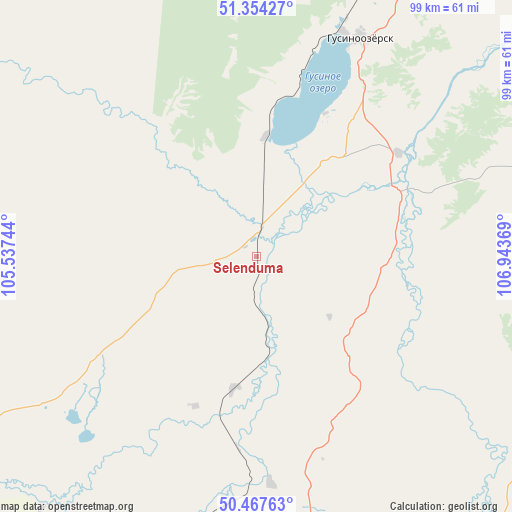
Selenduma GPS coordinates[2]
50° 54' 47.016" North, 106° 14' 26.016" East
| Map corner | latitude | longitude |
|---|---|---|
| Upper-left | 51.35427°, | 105.53744° |
| Center: | 50.91306°, | 106.24056° |
| Lower-right: | 50.46763°, | 106.94369° |
| Map W x H: | 98.6×98.6 km | = 61.3×61.3mi |
| max Lat: | 73.50819° ⇑75.3% North |
| Selenduma: | 50.91306° |
| min Lat: | ⇓24.7% South 41.28413° |
| min Long | Selenduma | max Long |
| -179.12198° | 106.24056° | 179.35046° |
| W 90.1%⇐ | ⇒9.9% E |
Elevation
Elevation of Selenduma is 556 m = 1824 ft, and this is 353.4 m = 1159 ft above average elevation for this country.
| Max E: |
2518 m = 8261 ft | 6.5% |
| Selenduma | 556 m 1824 ft | |
| Avg. | 202.6 m = 665 ft | |
Min E: |
-28 m = -92 ft | 93.5% |
See also: Russia elevation on elevation.city.
Geographical zone
Selenduma is located in North temperate zone (between Tropic of Cancer and the Arctic Circle). Distance of this North polar circle is 1740.2 km =1081.3 mi to North.| Distance of | km | miles | from Selenduma |
|---|---|---|---|
| North Pole | 4346.1 | 2700.5 | to North |
| Arctic Circle | 1740.2 | 1081.3 | to North |
| Tropic Cancer | 3055.1 | 1898.4 | to South |
| Equator | 5661 | 3517.6 | to South |


Nearby cities:
15 places around Selenduma: (largest is in red/bold)
• Babushkin
92.6 km =57.5 mi,  343°
343°
• Bichura
102.4 km =63.6 mi,  110°
110°
• Chikoy
86.4 km =53.7 mi,  146°
146°
• Dzhida
26.6 km =16.5 mi,  189°
189°
• Gashey
80.4 km =50 mi,  79°
79°
• Gusinoozyorsk
45 km =28 mi,  23°
23°
• Gusinoye Ozero
22.4 km =13.9 mi,  3°
3°
• Kyakhta
63.5 km =39.5 mi,  166°
166°
• Naushki
59.7 km =37.1 mi, 189°
• Novosretenka
103.9 km =64.6 mi,  102°
102°
• Okino-Klyuchi
70.7 km =43.9 mi,  120°
120°
• Petropavlovka
72.9 km =45.3 mi,  242°
242°
• Sharalday
99.1 km =61.6 mi, 82°
• Tankhoy
105.6 km =65.6 mi,  312°
312°
• Tarbagatay
100.5 km =62.4 mi,  50°
50°
Sources, notices
• [Note1] Compared only with cities in Russia existing in our database
• [Src1] Map data: © OpenStreetMap contributors (CC-BY-SA)
• [Src2] Other city data from geonames.org with taken over terms of usage.
• [Src3] Geographical zone / Annual Mean Temperature by Robert A. Rohde @ Wikipedia
