Novaya Igirma geodata
Novaya Igirma (Irkutsk Oblast) is a populated place; located in Russia in Asia/Irkutsk (GMT+8) time zone. With population of 10,681 people, there are 1412 cities with bigger population in this country. Compared to other cities in Russia, 78.2% of cities are located further ↓South; 89.3% of cities are located further ←West and 84.4% of cities have lower elevation than Novaya Igirma. Note1


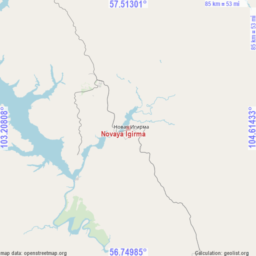
Novaya Igirma GPS coordinates[2]
57° 8' 0.24" North, 103° 54' 40.32" East
| Map corner | latitude | longitude |
|---|---|---|
| Upper-left | 57.51301°, | 103.20808° |
| Center: | 57.1334°, | 103.9112° |
| Lower-right: | 56.74985°, | 104.61433° |
| Map W x H: | 84.9×84.9 km | = 52.8×52.8mi |
| max Lat: | 73.50819° ⇑21.8% North |
| Novaya Igirma: | 57.1334° |
| min Lat: | ⇓78.2% South 41.28413° |
| min Long | Novaya Igirma | max Long |
| -179.12198° | 103.9112° | 179.35046° |
| W 89.3%⇐ | ⇒10.7% E |
Elevation
Elevation of Novaya Igirma is 312 m = 1024 ft, and this is 109.4 m = 359 ft above average elevation for this country.
| Max E: |
2518 m = 8261 ft | 15.6% |
| Novaya Igirma | 312 m 1024 ft | |
| Avg. | 202.6 m = 665 ft | |
Min E: |
-28 m = -92 ft | 84.4% |
See also: Russia elevation on elevation.city.
Geographical zone
Novaya Igirma is located in North temperate zone (between Tropic of Cancer and the Arctic Circle). Distance of this North polar circle is 1048.5 km =651.5 mi to North.| Distance of | km | miles | from Novaya Igirma |
|---|---|---|---|
| North Pole | 3654.4 | 2270.7 | to North |
| Arctic Circle | 1048.5 | 651.5 | to North |
| Tropic Cancer | 3746.7 | 2328.1 | to South |
| Equator | 6352.6 | 3947.3 | to South |


Nearby cities:
15 places around Novaya Igirma: (largest is in red/bold)
• Bereznyaki
29.5 km =18.3 mi,  222°
222°
• Bratsk
179.2 km =111.3 mi,  231°
231°
• Khrebtovaya
52.1 km =32.4 mi,  156°
156°
• Magistral’nyy
240.8 km =149.6 mi,  116°
116°
• Markovo
192.3 km =119.5 mi,  83°
83°
• Rudnogorsk
17.4 km =10.8 mi,  326°
326°
• Shestakovo
71.4 km =44.4 mi,  177°
177°
• Ust’-Ilimsk
121.8 km =75.7 mi,  322°
322°
• Ust’-Kut
118.7 km =73.8 mi,  108°
108°
• Vidim
94.2 km =58.5 mi,  211°
211°
• Vikhorevka
201.5 km =125.2 mi,  236°
236°
• Yantal’
87.4 km =54.3 mi, 111°
• Zheleznodorozhnyy
109.3 km =67.9 mi, 321°
• Zheleznogorsk-Ilimskiy
63.2 km =39.3 mi,  168°
168°
• Zvëzdnyy
161.5 km =100.4 mi, 105°
Sources, notices
• [Note1] Compared only with cities in Russia existing in our database
• [Src1] Map data: © OpenStreetMap contributors (CC-BY-SA)
• [Src2] Other city data from geonames.org with taken over terms of usage.
• [Src3] Geographical zone / Annual Mean Temperature by Robert A. Rohde @ Wikipedia
