Magistral’nyy geodata
Magistral’nyy (Irkutsk Oblast) is a populated place; located in Russia in Asia/Irkutsk (GMT+8) time zone. With population of 7,638 people, there are 1879 cities with bigger population in this country. Compared to other cities in Russia, 68.9% of cities are located further ↓South; 90.5% of cities are located further ←West and 89% of cities have lower elevation than Magistral’nyy. Note1


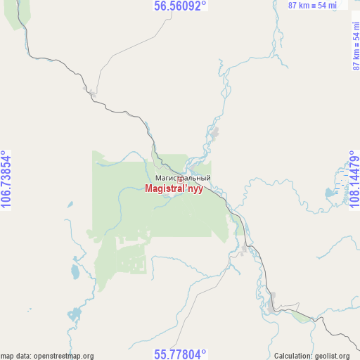
Magistral’nyy GPS coordinates[2]
56° 10' 17.328" North, 107° 26' 29.976" East
| Map corner | latitude | longitude |
|---|---|---|
| Upper-left | 56.56092°, | 106.73854° |
| Center: | 56.17148°, | 107.44166° |
| Lower-right: | 55.77804°, | 108.14479° |
| Map W x H: | 87×87 km | = 54.1×54.1mi |
| max Lat: | 73.50819° ⇑31.1% North |
| Magistral’nyy: | 56.17148° |
| min Lat: | ⇓68.9% South 41.28413° |
| min Long | Magistral’nyy | max Long |
| -179.12198° | 107.44166° | 179.35046° |
| W 90.5%⇐ | ⇒9.5% E |
Elevation
Elevation of Magistral’nyy is 428 m = 1404 ft, and this is 225.4 m = 740 ft above average elevation for this country.
| Max E: |
2518 m = 8261 ft | 11% |
| Magistral’nyy | 428 m 1404 ft | |
| Avg. | 202.6 m = 665 ft | |
Min E: |
-28 m = -92 ft | 89% |
See also: Russia elevation on elevation.city.
Geographical zone
Magistral’nyy is located in North temperate zone (between Tropic of Cancer and the Arctic Circle). Distance of this North polar circle is 1155.5 km =718 mi to North.| Distance of | km | miles | from Magistral’nyy |
|---|---|---|---|
| North Pole | 3761.4 | 2337.2 | to North |
| Arctic Circle | 1155.5 | 718 | to North |
| Tropic Cancer | 3639.8 | 2261.7 | to South |
| Equator | 6245.7 | 3880.9 | to South |


Nearby cities:
15 places around Magistral’nyy: (largest is in red/bold)
• Alekseyevskaya
195.4 km =121.4 mi,  17°
17°
• Kazachinskoye
13.7 km =8.5 mi,  37°
37°
• Khrebtovaya
204.9 km =127.3 mi,  286°
286°
• Kichera
167.1 km =103.8 mi,  98°
98°
• Kirensk
184 km =114.3 mi,  12°
12°
• Markovo
129.6 km =80.5 mi,  350°
350°
• Nizhneangarsk
139.5 km =86.7 mi,  107°
107°
• Novaya Igirma
240.8 km =149.6 mi,  296°
296°
• Severobaykal’sk
131.5 km =81.7 mi,  116°
116°
• Shestakovo
217.5 km =135.1 mi,  279°
279°
• Ust’-Kut
123.9 km =77 mi, 303°
• Yantal’
153.8 km =95.6 mi, 299°
• Zheleznogorsk-Ilimskiy
209.3 km =130.1 mi, 282°
• Zhigalovo
208.8 km =129.7 mi,  223°
223°
• Zvëzdnyy
87.3 km =54.2 mi,  317°
317°
Sources, notices
• [Note1] Compared only with cities in Russia existing in our database
• [Src1] Map data: © OpenStreetMap contributors (CC-BY-SA)
• [Src2] Other city data from geonames.org with taken over terms of usage.
• [Src3] Geographical zone / Annual Mean Temperature by Robert A. Rohde @ Wikipedia
