Lyalichi geodata
Lyalichi (Primorskiy (Maritime) Kray) is a populated place; located in Russia in Asia/Vladivostok (GMT+10) time zone. With population of 1,300 people, there are 4471 cities with bigger population in this country. Compared to other cities in Russia, 91.5% of cities are located further ↑North; 95.6% of cities are located further ←West and 75% of cities have higher elevation than Lyalichi. Note1


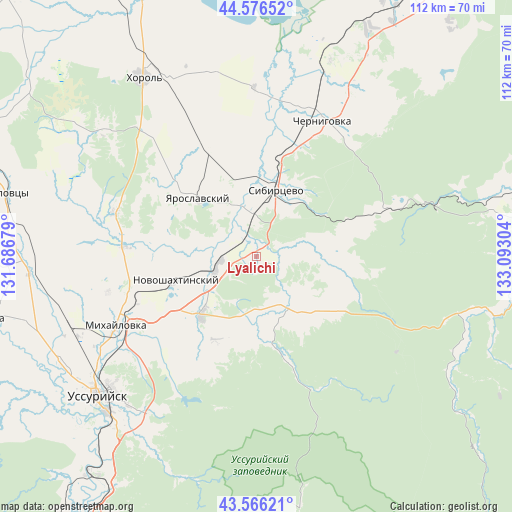
Lyalichi GPS coordinates[2]
44° 4' 24.672" North, 132° 23' 23.676" East
| Map corner | latitude | longitude |
|---|---|---|
| Upper-left | 44.57652°, | 131.68679° |
| Center: | 44.07352°, | 132.38991° |
| Lower-right: | 43.56621°, | 133.09304° |
| Map W x H: | 112.3×112.3 km | = 69.8×69.8mi |
| max Lat: | 73.50819° ⇑91.5% North |
| Lyalichi: | 44.07352° |
| min Lat: | ⇓8.5% South 41.28413° |
| min Long | Lyalichi | max Long |
| -179.12198° | 132.38991° | 179.35046° |
| W 95.6%⇐ | ⇒4.4% E |
Elevation
Elevation of Lyalichi is 88 m = 289 ft, and this is 114.6 m = 376 ft below average elevation for this country.
| Max E: |
2518 m = 8261 ft | 75% |
| Avg. | 202.6 m = 665 ft | |
| Lyalichi | 88 m = 289 ft | |
Min E: |
-28 m = -92 ft | 25% |
See also: Russia elevation on elevation.city.
Geographical zone
Lyalichi is located in North temperate zone (between Tropic of Cancer and the Arctic Circle). Distance of this Northern Tropic circle is 2294.6 km =1425.8 mi to South.| Distance of | km | miles | from Lyalichi |
|---|---|---|---|
| North Pole | 5106.5 | 3173 | to North |
| Arctic Circle | 2500.7 | 1553.9 | to North |
| Tropic Cancer | 2294.6 | 1425.8 | to South |
| Equator | 4900.5 | 3045 | to South |


Nearby cities:
15 places around Lyalichi: (largest is in red/bold)
• Blagodatnoye
36.6 km =22.7 mi,  319°
319°
• Chernigovka
33.1 km =20.6 mi,  25°
25°
• Grigor’yevka
33.1 km =20.6 mi,  287°
287°
• Ivanovka
13.8 km =8.6 mi,  147°
147°
• Khorol’
46.5 km =28.9 mi,  327°
327°
• Luchki
25.8 km =16 mi,  336°
336°
• Mikhaylovka
34.2 km =21.3 mi,  242°
242°
• Monastyrishche
16.3 km =10.1 mi, 33°
• Novonikol’sk
48.7 km =30.3 mi, 240°
• Novoshakhtinskiy
18.7 km =11.6 mi,  253°
253°
• Rettikhovka
32.3 km =20.1 mi,  70°
70°
• Sivakovka
45.1 km =28 mi,  357°
357°
• Ussuriysk
46.6 km =29 mi,  229°
229°
• Vozdvizhenka
40.7 km =25.3 mi, 240°
• Yaroslavskiy
17.9 km =11.1 mi,  314°
314°
Sources, notices
• [Note1] Compared only with cities in Russia existing in our database
• [Src1] Map data: © OpenStreetMap contributors (CC-BY-SA)
• [Src2] Other city data from geonames.org with taken over terms of usage.
• [Src3] Geographical zone / Annual Mean Temperature by Robert A. Rohde @ Wikipedia
