Khorol’ geodata
Khorol’ (Primorskiy (Maritime) Kray) is a populated place; located in Russia in Asia/Vladivostok (GMT+10) time zone. With population of 11,245 people, there are 1343 cities with bigger population in this country. Compared to other cities in Russia, 89.6% of cities are located further ↑North; 95.3% of cities are located further ←West and 66.6% of cities have higher elevation than Khorol’. Note1


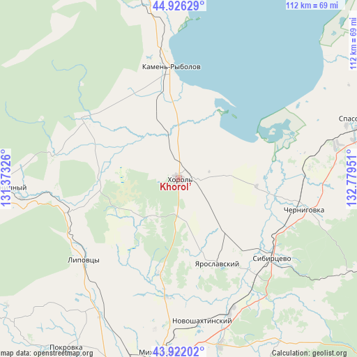
Khorol’ GPS coordinates[2]
44° 25' 34.716" North, 132° 4' 34.968" East
| Map corner | latitude | longitude |
|---|---|---|
| Upper-left | 44.92629°, | 131.37326° |
| Center: | 44.42631°, | 132.07638° |
| Lower-right: | 43.92202°, | 132.77951° |
| Map W x H: | 111.7×111.7 km | = 69.4×69.4mi |
| max Lat: | 73.50819° ⇑89.6% North |
| Khorol’: | 44.42631° |
| min Lat: | ⇓10.4% South 41.28413° |
| min Long | Khorol’ | max Long |
| -179.12198° | 132.07638° | 179.35046° |
| W 95.3%⇐ | ⇒4.7% E |
Elevation
Elevation of Khorol’ is 110 m = 361 ft, and this is 92.6 m = 304 ft below average elevation for this country.
| Max E: |
2518 m = 8261 ft | 66.6% |
| Avg. | 202.6 m = 665 ft | |
| Khorol’ | 110 m = 361 ft | |
Min E: |
-28 m = -92 ft | 33.4% |
See also: Russia elevation on elevation.city.
Geographical zone
Khorol’ is located in North temperate zone (between Tropic of Cancer and the Arctic Circle). Distance of this Northern Tropic circle is 2333.8 km =1450.2 mi to South.| Distance of | km | miles | from Khorol’ |
|---|---|---|---|
| North Pole | 5067.3 | 3148.7 | to North |
| Arctic Circle | 2461.4 | 1529.4 | to North |
| Tropic Cancer | 2333.8 | 1450.2 | to South |
| Equator | 4939.7 | 3069.4 | to South |


Nearby cities:
15 places around Khorol’: (largest is in red/bold)
• Blagodatnoye
11.6 km =7.2 mi,  174°
174°
• Chernigovka
40.3 km =25 mi,  103°
103°
• Grigor’yevka
30.2 km =18.8 mi,  192°
192°
• Kamen’-Rybolov
35.5 km =22.1 mi,  356°
356°
• Lipovtsy
37.7 km =23.4 mi,  228°
228°
• Luchki
21.3 km =13.2 mi,  136°
136°
• Lyalichi
46.5 km =28.9 mi,  147°
147°
• Mel’gunovka
19.4 km =12.1 mi,  327°
327°
• Mikhaylovka
55.1 km =34.2 mi, 185°
• Monastyrishche
42.4 km =26.3 mi,  127°
127°
• Novoshakhtinskiy
45.1 km =28 mi, 170°
• Sergeyevka
34.4 km =21.4 mi,  253°
253°
• Sivakovka
23.8 km =14.8 mi,  75°
75°
• Yaroslavskiy
29.4 km =18.3 mi,  155°
155°
• Zharikovo
33 km =20.5 mi,  303°
303°
Sources, notices
• [Note1] Compared only with cities in Russia existing in our database
• [Src1] Map data: © OpenStreetMap contributors (CC-BY-SA)
• [Src2] Other city data from geonames.org with taken over terms of usage.
• [Src3] Geographical zone / Annual Mean Temperature by Robert A. Rohde @ Wikipedia
