Luchki geodata
Luchki (Primorskiy (Maritime) Kray) is a populated place; located in Russia in Asia/Vladivostok (GMT+10) time zone. With population of 1,131 people, there are 4558 cities with bigger population in this country. Compared to other cities in Russia, 90.2% of cities are located further ↑North; 95.5% of cities are located further ←West and 74.6% of cities have higher elevation than Luchki. Note1


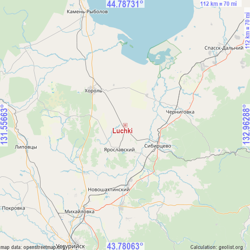
Luchki GPS coordinates[2]
44° 17' 10.068" North, 132° 15' 35.1" East
| Map corner | latitude | longitude |
|---|---|---|
| Upper-left | 44.78731°, | 131.55663° |
| Center: | 44.28613°, | 132.25975° |
| Lower-right: | 43.78063°, | 132.96288° |
| Map W x H: | 111.9×111.9 km | = 69.5×69.5mi |
| max Lat: | 73.50819° ⇑90.2% North |
| Luchki: | 44.28613° |
| min Lat: | ⇓9.8% South 41.28413° |
| min Long | Luchki | max Long |
| -179.12198° | 132.25975° | 179.35046° |
| W 95.5%⇐ | ⇒4.5% E |
Elevation
Elevation of Luchki is 89 m = 292 ft, and this is 113.6 m = 373 ft below average elevation for this country.
| Max E: |
2518 m = 8261 ft | 74.6% |
| Avg. | 202.6 m = 665 ft | |
| Luchki | 89 m = 292 ft | |
Min E: |
-28 m = -92 ft | 25.4% |
See also: Russia elevation on elevation.city.
Geographical zone
Luchki is located in North temperate zone (between Tropic of Cancer and the Arctic Circle). Distance of this Northern Tropic circle is 2318.2 km =1440.5 mi to South.| Distance of | km | miles | from Luchki |
|---|---|---|---|
| North Pole | 5082.9 | 3158.4 | to North |
| Arctic Circle | 2477 | 1539.1 | to North |
| Tropic Cancer | 2318.2 | 1440.5 | to South |
| Equator | 4924.2 | 3059.8 | to South |


Nearby cities:
15 places around Luchki: (largest is in red/bold)
• Blagodatnoye
14.1 km =8.8 mi,  286°
286°
• Chernigovka
25.4 km =15.8 mi,  75°
75°
• Grigor’yevka
25.3 km =15.7 mi,  236°
236°
• Ivanovka
39.5 km =24.5 mi,  153°
153°
• Khorol’
21.3 km =13.2 mi,  316°
316°
• Lipovtsy
43.8 km =27.2 mi,  257°
257°
• Lyalichi
25.8 km =16 mi,  156°
156°
• Mel’gunovka
40.6 km =25.2 mi, 321°
• Mikhaylovka
44.1 km =27.4 mi,  206°
206°
• Monastyrishche
21.7 km =13.5 mi,  117°
117°
• Novoshakhtinskiy
29.9 km =18.6 mi,  194°
194°
• Rettikhovka
42.7 km =26.5 mi,  107°
107°
• Sergeyevka
48 km =29.8 mi,  276°
276°
• Sivakovka
23 km =14.3 mi,  21°
21°
• Yaroslavskiy
11.4 km =7.1 mi, 192°
Sources, notices
• [Note1] Compared only with cities in Russia existing in our database
• [Src1] Map data: © OpenStreetMap contributors (CC-BY-SA)
• [Src2] Other city data from geonames.org with taken over terms of usage.
• [Src3] Geographical zone / Annual Mean Temperature by Robert A. Rohde @ Wikipedia
