Khor geodata
Khor (Khabarovsk) is a populated place; located in Russia in Asia/Vladivostok (GMT+10) time zone. With population of 11,503 people, there are 1322 cities with bigger population in this country. Compared to other cities in Russia, 80.6% of cities are located further ↑North; 96.8% of cities are located further ←West and 82.8% of cities have higher elevation than Khor. Note1


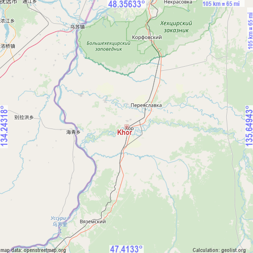
Khor GPS coordinates[2]
47° 53' 13.056" North, 134° 56' 46.68" East
| Map corner | latitude | longitude |
|---|---|---|
| Upper-left | 48.35633°, | 134.24318° |
| Center: | 47.88696°, | 134.9463° |
| Lower-right: | 47.4133°, | 135.64943° |
| Map W x H: | 104.9×104.9 km | = 65.2×65.2mi |
| max Lat: | 73.50819° ⇑80.6% North |
| Khor: | 47.88696° |
| min Lat: | ⇓19.4% South 41.28413° |
| min Long | Khor | max Long |
| -179.12198° | 134.9463° | 179.35046° |
| W 96.8%⇐ | ⇒3.2% E |
Elevation
Elevation of Khor is 59 m = 194 ft, and this is 143.6 m = 471 ft below average elevation for this country.
| Max E: |
2518 m = 8261 ft | 82.8% |
| Avg. | 202.6 m = 665 ft | |
| Khor | 59 m = 194 ft | |
Min E: |
-28 m = -92 ft | 17.2% |
See also: Russia elevation on elevation.city.
Geographical zone
Khor is located in North temperate zone (between Tropic of Cancer and the Arctic Circle). Distance of this North polar circle is 2076.6 km =1290.3 mi to North.| Distance of | km | miles | from Khor |
|---|---|---|---|
| North Pole | 4682.5 | 2909.6 | to North |
| Arctic Circle | 2076.6 | 1290.3 | to North |
| Tropic Cancer | 2718.6 | 1689.3 | to South |
| Equator | 5324.5 | 3308.5 | to South |


Nearby cities:
15 places around Khor: (largest is in red/bold)
• Bikin
130.4 km =81 mi,  203°
203°
• Khabarovsk
67 km =41.6 mi,  8°
8°
• Khabarovsk Vtoroy
62.8 km =39 mi, 12°
• Knyaze-Volkonskoye
74.6 km =46.4 mi,  30°
30°
• Korfovskiy
38.3 km =23.8 mi, 12°
• Lermontovka
94.1 km =58.5 mi,  209°
209°
• Litovko
151.1 km =93.9 mi, 6°
• Mukhen
94.3 km =58.6 mi,  68°
68°
• Nekrasovka
55.9 km =34.7 mi,  22°
22°
• Priamurskiy
71.3 km =44.3 mi,  357°
357°
• Sinda
156 km =96.9 mi,  40°
40°
• Smidovich
115.4 km =71.7 mi,  313°
313°
• Topolëvo
70.5 km =43.8 mi, 13°
• Volochayevka Vtoraya
80.3 km =49.9 mi,  340°
340°
• Vyazemskiy
41.4 km =25.7 mi, 200°
Sources, notices
• [Note1] Compared only with cities in Russia existing in our database
• [Src1] Map data: © OpenStreetMap contributors (CC-BY-SA)
• [Src2] Other city data from geonames.org with taken over terms of usage.
• [Src3] Geographical zone / Annual Mean Temperature by Robert A. Rohde @ Wikipedia
