Khabarovsk geodata
Khabarovsk is a seat of a first-order administrative division; located in Russia in Asia/Vladivostok (GMT+10) time zone. With population of 579,000 people, there are 24 cities with bigger population in this country. Compared to other cities in Russia, 79.8% of cities are located further ↑North; 96.9% of cities are located further ←West and 78.4% of cities have higher elevation than Khabarovsk. Note1


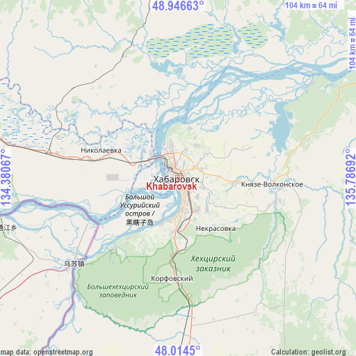
Khabarovsk GPS coordinates[2]
48° 28' 57.756" North, 135° 5' 1.644" East
| Map corner | latitude | longitude |
|---|---|---|
| Upper-left | 48.94663°, | 134.38067° |
| Center: | 48.48271°, | 135.08379° |
| Lower-right: | 48.0145°, | 135.78692° |
| Map W x H: | 103.6×103.6 km | = 64.4×64.4mi |
| max Lat: | 73.50819° ⇑79.8% North |
| Khabarovsk: | 48.48271° |
| min Lat: | ⇓20.2% South 41.28413° |
| min Long | Khabarovsk | max Long |
| -179.12198° | 135.08379° | 179.35046° |
| W 96.9%⇐ | ⇒3.1% E |
Elevation
Elevation of Khabarovsk is 76 m = 249 ft, and this is 126.6 m = 415 ft below average elevation for this country.
| Max E: |
2518 m = 8261 ft | 78.4% |
| Avg. | 202.6 m = 665 ft | |
| Khabarovsk | 76 m = 249 ft | |
Min E: |
-28 m = -92 ft | 21.6% |
See also: Khabarovsk elevation on elevation.city.
Geographical zone
Khabarovsk is located in North temperate zone (between Tropic of Cancer and the Arctic Circle). Distance of this North polar circle is 2010.4 km =1249.2 mi to North.| Distance of | km | miles | from Khabarovsk |
|---|---|---|---|
| North Pole | 4616.3 | 2868.4 | to North |
| Arctic Circle | 2010.4 | 1249.2 | to North |
| Tropic Cancer | 2784.9 | 1730.5 | to South |
| Equator | 5390.8 | 3349.7 | to South |


Nearby cities:
15 places around Khabarovsk: (largest is in red/bold)
• Birobidzhan
162.4 km =100.9 mi,  282°
282°
• Khabarovsk Vtoroy
6.2 km =3.9 mi,  143°
143°
• Khor
67 km =41.6 mi,  188°
188°
• Knyaze-Volkonskoye
27.5 km =17.1 mi,  93°
93°
• Korfovskiy
29 km =18 mi,  183°
183°
• Lermontovka
158.6 km =98.5 mi,  200°
200°
• Litovko
84.2 km =52.3 mi,  4°
4°
• Mukhen
83.4 km =51.8 mi,  112°
112°
• Nekrasovka
18.2 km =11.3 mi, 142°
• Priamurskiy
14.2 km =8.8 mi,  290°
290°
• Sinda
104.3 km =64.8 mi,  59°
59°
• Smidovich
94.7 km =58.8 mi, 277°
• Topolëvo
7.2 km =4.5 mi,  71°
71°
• Volochayevka Vtoraya
38.1 km =23.7 mi, 284°
• Vyazemskiy
107.9 km =67 mi, 193°
In other languages:
- In Spanish: Jabárovsk
- In German: Chabarowsk
- In Italian: Habarovsk, Chabarovsk
- In Russian: Хабаровск
- In Chinese: 伯力
Sources, notices
• [Note1] Compared only with cities in Russia existing in our database
• [Src1] Map data: © OpenStreetMap contributors (CC-BY-SA)
• [Src2] Other city data from geonames.org with taken over terms of usage.
• [Src3] Geographical zone / Annual Mean Temperature by Robert A. Rohde @ Wikipedia
