Nekrasovka geodata
Nekrasovka (Khabarovsk) is a populated place; located in Russia in Asia/Vladivostok (GMT+10) time zone. With population of 9,159 people, there are 1630 cities with bigger population in this country. Compared to other cities in Russia, 80% of cities are located further ↑North; 97% of cities are located further ←West and 76.7% of cities have higher elevation than Nekrasovka. Note1


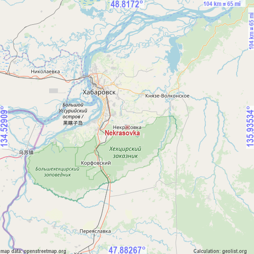
Nekrasovka GPS coordinates[2]
48° 21' 7.488" North, 135° 13' 55.956" East
| Map corner | latitude | longitude |
|---|---|---|
| Upper-left | 48.8172°, | 134.52909° |
| Center: | 48.35208°, | 135.23221° |
| Lower-right: | 47.88267°, | 135.93534° |
| Map W x H: | 103.9×103.9 km | = 64.6×64.6mi |
| max Lat: | 73.50819° ⇑80% North |
| Nekrasovka: | 48.35208° |
| min Lat: | ⇓20% South 41.28413° |
| min Long | Nekrasovka | max Long |
| -179.12198° | 135.23221° | 179.35046° |
| W 97%⇐ | ⇒3% E |
Elevation
Elevation of Nekrasovka is 82 m = 269 ft, and this is 120.6 m = 396 ft below average elevation for this country.
| Max E: |
2518 m = 8261 ft | 76.7% |
| Avg. | 202.6 m = 665 ft | |
| Nekrasovka | 82 m = 269 ft | |
Min E: |
-28 m = -92 ft | 23.3% |
See also: Russia elevation on elevation.city.
Geographical zone
Nekrasovka is located in North temperate zone (between Tropic of Cancer and the Arctic Circle). Distance of this North polar circle is 2024.9 km =1258.2 mi to North.| Distance of | km | miles | from Nekrasovka |
|---|---|---|---|
| North Pole | 4630.8 | 2877.4 | to North |
| Arctic Circle | 2024.9 | 1258.2 | to North |
| Tropic Cancer | 2770.3 | 1721.4 | to South |
| Equator | 5376.2 | 3340.6 | to South |


Nearby cities:
15 places around Nekrasovka: (largest is in red/bold)
• Birobidzhan
176.7 km =109.8 mi,  286°
286°
• Khabarovsk
18.2 km =11.3 mi,  322°
322°
• Khabarovsk Vtoroy
12 km =7.5 mi, 322°
• Khor
55.9 km =34.7 mi,  202°
202°
• Knyaze-Volkonskoye
20.8 km =12.9 mi,  52°
52°
• Korfovskiy
19.2 km =11.9 mi,  221°
221°
• Lermontovka
149.8 km =93.1 mi,  206°
206°
• Litovko
98.5 km =61.2 mi,  357°
357°
• Mukhen
68.4 km =42.5 mi,  104°
104°
• Priamurskiy
31.1 km =19.3 mi,  308°
308°
• Sinda
103.9 km =64.6 mi, 49°
• Smidovich
108.4 km =67.4 mi,  284°
284°
• Topolëvo
17.2 km =10.7 mi,  346°
346°
• Volochayevka Vtoraya
53.5 km =33.2 mi,  296°
296°
• Vyazemskiy
97.3 km =60.5 mi, 201°
Sources, notices
• [Note1] Compared only with cities in Russia existing in our database
• [Src1] Map data: © OpenStreetMap contributors (CC-BY-SA)
• [Src2] Other city data from geonames.org with taken over terms of usage.
• [Src3] Geographical zone / Annual Mean Temperature by Robert A. Rohde @ Wikipedia
