Topolëvo geodata
Topolëvo (Khabarovsk) is a populated place; located in Russia in Asia/Vladivostok (GMT+10) time zone. With population of 4,117 people, there are 3046 cities with bigger population in this country. Compared to other cities in Russia, 79.8% of cities are located further ↑North; 97% of cities are located further ←West and 81.7% of cities have higher elevation than Topolëvo. Note1


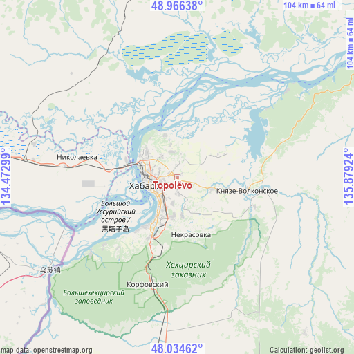
Topolëvo GPS coordinates[2]
48° 30' 9.504" North, 135° 10' 33.996" East
| Map corner | latitude | longitude |
|---|---|---|
| Upper-left | 48.96638°, | 134.47299° |
| Center: | 48.50264°, | 135.17611° |
| Lower-right: | 48.03462°, | 135.87924° |
| Map W x H: | 103.6×103.6 km | = 64.4×64.4mi |
| max Lat: | 73.50819° ⇑79.8% North |
| Topolëvo: | 48.50264° |
| min Lat: | ⇓20.2% South 41.28413° |
| min Long | Topolëvo | max Long |
| -179.12198° | 135.17611° | 179.35046° |
| W 97%⇐ | ⇒3% E |
Elevation
Elevation of Topolëvo is 65 m = 213 ft, and this is 137.6 m = 451 ft below average elevation for this country.
| Max E: |
2518 m = 8261 ft | 81.7% |
| Avg. | 202.6 m = 665 ft | |
| Topolëvo | 65 m = 213 ft | |
Min E: |
-28 m = -92 ft | 18.3% |
See also: Russia elevation on elevation.city.
Geographical zone
Topolëvo is located in North temperate zone (between Tropic of Cancer and the Arctic Circle). Distance of this North polar circle is 2008.2 km =1247.8 mi to North.| Distance of | km | miles | from Topolëvo |
|---|---|---|---|
| North Pole | 4614.1 | 2867.1 | to North |
| Arctic Circle | 2008.2 | 1247.8 | to North |
| Tropic Cancer | 2787.1 | 1731.8 | to South |
| Equator | 5393 | 3351.1 | to South |


Nearby cities:
15 places around Topolëvo: (largest is in red/bold)
• Birobidzhan
168.6 km =104.8 mi,  281°
281°
• Khabarovsk
7.2 km =4.5 mi,  251°
251°
• Khabarovsk Vtoroy
7.9 km =4.9 mi,  203°
203°
• Khor
70.5 km =43.8 mi,  193°
193°
• Knyaze-Volkonskoye
21 km =13 mi,  101°
101°
• Korfovskiy
32.3 km =20.1 mi, 195°
• Lermontovka
163.2 km =101.4 mi, 202°
• Litovko
81.7 km =50.8 mi,  359°
359°
• Mukhen
78.1 km =48.5 mi,  115°
115°
• Nekrasovka
17.2 km =10.7 mi,  166°
166°
• Priamurskiy
20.3 km =12.6 mi, 277°
• Sinda
97.3 km =60.5 mi,  58°
58°
• Smidovich
101.2 km =62.9 mi, 275°
• Volochayevka Vtoraya
44.3 km =27.5 mi, 279°
• Vyazemskiy
111.8 km =69.5 mi, 196°
Sources, notices
• [Note1] Compared only with cities in Russia existing in our database
• [Src1] Map data: © OpenStreetMap contributors (CC-BY-SA)
• [Src2] Other city data from geonames.org with taken over terms of usage.
• [Src3] Geographical zone / Annual Mean Temperature by Robert A. Rohde @ Wikipedia
