Birobidzhan geodata
Birobidzhan (Jewish Autonomous Oblast) is a seat of a first-order administrative division; located in Russia in Asia/Vladivostok (GMT+10) time zone. With population of 76,146 people, there are 269 cities with bigger population in this country. Compared to other cities in Russia, 79.3% of cities are located further ↑North; 96.1% of cities are located further ←West and 75.5% of cities have higher elevation than Birobidzhan. Note1


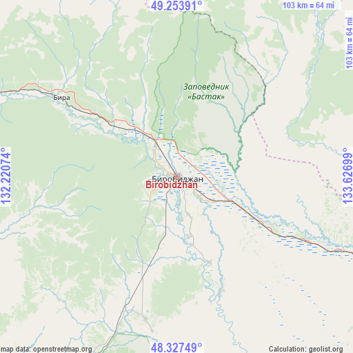
Birobidzhan GPS coordinates[2]
48° 47' 34.224" North, 132° 55' 25.896" East
| Map corner | latitude | longitude |
|---|---|---|
| Upper-left | 49.25391°, | 132.22074° |
| Center: | 48.79284°, | 132.92386° |
| Lower-right: | 48.32749°, | 133.62699° |
| Map W x H: | 103×103 km | = 64×64mi |
| max Lat: | 73.50819° ⇑79.3% North |
| Birobidzhan: | 48.79284° |
| min Lat: | ⇓20.7% South 41.28413° |
| min Long | Birobidzhan | max Long |
| -179.12198° | 132.92386° | 179.35046° |
| W 96.1%⇐ | ⇒3.9% E |
Elevation
Elevation of Birobidzhan is 86 m = 282 ft, and this is 116.6 m = 383 ft below average elevation for this country.
| Max E: |
2518 m = 8261 ft | 75.5% |
| Avg. | 202.6 m = 665 ft | |
| Birobidzhan | 86 m = 282 ft | |
Min E: |
-28 m = -92 ft | 24.5% |
See also: Birobidzhan elevation on elevation.city.
Geographical zone
Birobidzhan is located in North temperate zone (between Tropic of Cancer and the Arctic Circle). Distance of this North polar circle is 1975.9 km =1227.8 mi to North.| Distance of | km | miles | from Birobidzhan |
|---|---|---|---|
| North Pole | 4581.8 | 2847 | to North |
| Arctic Circle | 1975.9 | 1227.8 | to North |
| Tropic Cancer | 2819.3 | 1751.8 | to South |
| Equator | 5425.3 | 3371.1 | to South |


Nearby cities:
15 places around Birobidzhan: (largest is in red/bold)
• Babstovo
81.8 km =50.8 mi,  203°
203°
• Bira
40.6 km =25.2 mi,  304°
304°
• Birakan
90.8 km =56.4 mi,  284°
284°
• Izvestkovyy
102.4 km =63.6 mi, 281°
• Khabarovsk
162.4 km =100.9 mi,  102°
102°
• Khabarovsk Vtoroy
167.1 km =103.8 mi, 103°
• Khingansk
131.7 km =81.8 mi,  286°
286°
• Kul’dur
104.4 km =64.9 mi, 296°
• Leninskoye
98 km =60.9 mi,  193°
193°
• Londoko
72.6 km =45.1 mi, 290°
• Priamurskiy
148.4 km =92.2 mi, 101°
• Smidovich
68.5 km =42.6 mi,  108°
108°
• Topolëvo
168.6 km =104.8 mi, 101°
• Tyrma
150.3 km =93.4 mi,  338°
338°
• Volochayevka Vtoraya
124.3 km =77.2 mi, 101°
In other languages:
- In Spanish: Birobidzhán
- In France: Birobidjan
- In German: Birobidschan
- In Italian: Birobidžan
- In Russian: Биробиджан
- In Chinese: 比罗比詹
Sources, notices
• [Note1] Compared only with cities in Russia existing in our database
• [Src1] Map data: © OpenStreetMap contributors (CC-BY-SA)
• [Src2] Other city data from geonames.org with taken over terms of usage.
• [Src3] Geographical zone / Annual Mean Temperature by Robert A. Rohde @ Wikipedia
