Kul’dur geodata
Kul’dur (Jewish Autonomous Oblast) is a populated place; located in Russia in Asia/Vladivostok (GMT+10) time zone. With population of 1,957 people, there are 4192 cities with bigger population in this country. Compared to other cities in Russia, 78.8% of cities are located further ↑North; 94.7% of cities are located further ←West and 87.2% of cities have lower elevation than Kul’dur. Note1


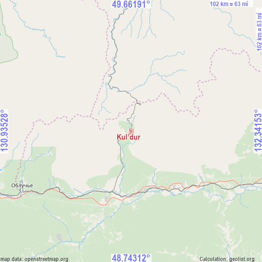
Kul’dur GPS coordinates[2]
49° 12' 16.74" North, 131° 38' 18.24" East
| Map corner | latitude | longitude |
|---|---|---|
| Upper-left | 49.66191°, | 130.93528° |
| Center: | 49.20465°, | 131.6384° |
| Lower-right: | 48.74312°, | 132.34153° |
| Map W x H: | 102.2×102.2 km | = 63.5×63.5mi |
| max Lat: | 73.50819° ⇑78.8% North |
| Kul’dur: | 49.20465° |
| min Lat: | ⇓21.2% South 41.28413° |
| min Long | Kul’dur | max Long |
| -179.12198° | 131.6384° | 179.35046° |
| W 94.7%⇐ | ⇒5.3% E |
Elevation
Elevation of Kul’dur is 374 m = 1227 ft, and this is 171.4 m = 562 ft above average elevation for this country.
| Max E: |
2518 m = 8261 ft | 12.8% |
| Kul’dur | 374 m 1227 ft | |
| Avg. | 202.6 m = 665 ft | |
Min E: |
-28 m = -92 ft | 87.2% |
See also: Russia elevation on elevation.city.
Geographical zone
Kul’dur is located in North temperate zone (between Tropic of Cancer and the Arctic Circle). Distance of this North polar circle is 1930.1 km =1199.3 mi to North.| Distance of | km | miles | from Kul’dur |
|---|---|---|---|
| North Pole | 4536 | 2818.5 | to North |
| Arctic Circle | 1930.1 | 1199.3 | to North |
| Tropic Cancer | 2865.1 | 1780.3 | to South |
| Equator | 5471 | 3399.5 | to South |


Nearby cities:
15 places around Kul’dur: (largest is in red/bold)
• Arkhara
115.2 km =71.6 mi,  282°
282°
• Babstovo
135.6 km =84.3 mi,  152°
152°
• Bira
64.5 km =40.1 mi,  110°
110°
• Birakan
24.3 km =15.1 mi,  165°
165°
• Birobidzhan
104.4 km =64.9 mi,  116°
116°
• Bureya
148.1 km =92 mi,  297°
297°
• Izvestkovyy
25.7 km =16 mi,  194°
194°
• Khingansk
33.5 km =20.8 mi,  255°
255°
• Leninskoye
158.6 km =98.5 mi, 152°
• Londoko
33 km =20.5 mi,  128°
128°
• Novobureyskiy
143.4 km =89.1 mi, 297°
• Novoraychikhinsk
161.3 km =100.2 mi,  293°
293°
• Shirokiy
165 km =102.5 mi, 291°
• Talakan
153.5 km =95.4 mi,  320°
320°
• Tyrma
100.7 km =62.6 mi,  21°
21°
Sources, notices
• [Note1] Compared only with cities in Russia existing in our database
• [Src1] Map data: © OpenStreetMap contributors (CC-BY-SA)
• [Src2] Other city data from geonames.org with taken over terms of usage.
• [Src3] Geographical zone / Annual Mean Temperature by Robert A. Rohde @ Wikipedia
