Pyt-Yakh geodata
Pyt-Yakh (Khanty-Mansia) is a populated place; located in Russia in Asia/Yekaterinburg (GMT+5) time zone. With population of 41,500 people, there are 507 cities with bigger population in this country. Compared to other cities in Russia, 92.5% of cities are located further ↓South; 77.5% of cities are located further ←West and 81.1% of cities have higher elevation than Pyt-Yakh. Note1


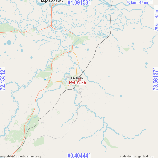
Pyt-Yakh GPS coordinates[2]
60° 44' 59.46" North, 72° 51' 29.664" East
| Map corner | latitude | longitude |
|---|---|---|
| Upper-left | 61.09158°, | 72.15512° |
| Center: | 60.74985°, | 72.85824° |
| Lower-right: | 60.40444°, | 73.56137° |
| Map W x H: | 76.4×76.4 km | = 47.5×47.5mi |
| max Lat: | 73.50819° ⇑7.5% North |
| Pyt-Yakh: | 60.74985° |
| min Lat: | ⇓92.5% South 41.28413° |
| min Long | Pyt-Yakh | max Long |
| -179.12198° | 72.85824° | 179.35046° |
| W 77.5%⇐ | ⇒22.5% E |
Elevation
Elevation of Pyt-Yakh is 67 m = 220 ft, and this is 135.6 m = 445 ft below average elevation for this country.
| Max E: |
2518 m = 8261 ft | 81.1% |
| Avg. | 202.6 m = 665 ft | |
| Pyt-Yakh | 67 m = 220 ft | |
Min E: |
-28 m = -92 ft | 18.9% |
See also: Pyt-Yakh elevation on elevation.city.
Geographical zone
Pyt-Yakh is located in North temperate zone (between Tropic of Cancer and the Arctic Circle). Distance of this North polar circle is 646.4 km =401.7 mi to North.| Distance of | km | miles | from Pyt-Yakh |
|---|---|---|---|
| North Pole | 3252.3 | 2020.9 | to North |
| Arctic Circle | 646.4 | 401.7 | to North |
| Tropic Cancer | 4148.8 | 2577.9 | to South |
| Equator | 6754.8 | 4197.2 | to South |


Nearby cities:
15 places around Pyt-Yakh: (largest is in red/bold)
• Barsovo
49.2 km =30.6 mi,  19°
19°
• Fedorovskiy
105.7 km =65.7 mi,  25°
25°
• Gornopravdinsk
180.1 km =111.9 mi,  244°
244°
• Langepas
138.7 km =86.2 mi,  66°
66°
• Lokosovo
114 km =70.8 mi, 68°
• Lyantor
103.8 km =64.5 mi,  338°
338°
• Megion
178.8 km =111.1 mi,  79°
79°
• Nefteyugansk
41.3 km =25.7 mi, 340°
• Pokachi
172.2 km =107 mi,  51°
51°
• Poykovskiy
59.5 km =37 mi, 25°
• Russkinskiye
161 km =100 mi,  14°
14°
• Salym
107.6 km =66.9 mi,  224°
224°
• Singapay
46.2 km =28.7 mi,  346°
346°
• Solnechniy
61.4 km =38.2 mi, 16°
• Surgut
63.2 km =39.3 mi, 28°
Sources, notices
• [Note1] Compared only with cities in Russia existing in our database
• [Src1] Map data: © OpenStreetMap contributors (CC-BY-SA)
• [Src2] Other city data from geonames.org with taken over terms of usage.
• [Src3] Geographical zone / Annual Mean Temperature by Robert A. Rohde @ Wikipedia
