Nefteyugansk geodata
Nefteyugansk (Khanty-Mansia) is a populated place; located in Russia in Asia/Yekaterinburg (GMT+5) time zone. With population of 112,632 people, there are 180 cities with bigger population in this country. Compared to other cities in Russia, 93.2% of cities are located further ↓South; 77.4% of cities are located further ←West and 84.9% of cities have higher elevation than Nefteyugansk. Note1


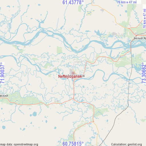
Nefteyugansk GPS coordinates[2]
61° 5' 59.244" North, 72° 36' 12.564" East
| Map corner | latitude | longitude |
|---|---|---|
| Upper-left | 61.43778°, | 71.90037° |
| Center: | 61.09979°, | 72.60349° |
| Lower-right: | 60.75815°, | 73.30662° |
| Map W x H: | 75.6×75.6 km | = 47×47mi |
| max Lat: | 73.50819° ⇑6.8% North |
| Nefteyugansk: | 61.09979° |
| min Lat: | ⇓93.2% South 41.28413° |
| min Long | Nefteyugansk | max Long |
| -179.12198° | 72.60349° | 179.35046° |
| W 77.4%⇐ | ⇒22.6% E |
Elevation
Elevation of Nefteyugansk is 48 m = 157 ft, and this is 154.6 m = 507 ft below average elevation for this country.
| Max E: |
2518 m = 8261 ft | 84.9% |
| Avg. | 202.6 m = 665 ft | |
| Nefteyugansk | 48 m = 157 ft | |
Min E: |
-28 m = -92 ft | 15.1% |
See also: Nefteyugansk elevation on elevation.city.
Geographical zone
Nefteyugansk is located in North temperate zone (between Tropic of Cancer and the Arctic Circle). Distance of this North polar circle is 607.5 km =377.5 mi to North.| Distance of | km | miles | from Nefteyugansk |
|---|---|---|---|
| North Pole | 3213.4 | 1996.7 | to North |
| Arctic Circle | 607.5 | 377.5 | to North |
| Tropic Cancer | 4187.7 | 2602.1 | to South |
| Equator | 6793.7 | 4221.4 | to South |


Nearby cities:
15 places around Nefteyugansk: (largest is in red/bold)
• Barsovo
31.1 km =19.3 mi,  76°
76°
• Fedorovskiy
81.7 km =50.8 mi,  46°
46°
• Kogalym
163 km =101.3 mi,  37°
37°
• Langepas
140.9 km =87.6 mi, 82°
• Lokosovo
118.9 km =73.9 mi,  88°
88°
• Lyantor
62.5 km =38.8 mi,  337°
337°
• Nizhnesortymskiy
155.4 km =96.6 mi, 343°
• Pokachi
162.4 km =100.9 mi,  64°
64°
• Poykovskiy
41.9 km =26 mi,  69°
69°
• Pyt-Yakh
41.3 km =25.7 mi,  160°
160°
• Russkinskiye
128.5 km =79.8 mi,  24°
24°
• Salym
130.7 km =81.2 mi,  208°
208°
• Singapay
6.8 km =4.2 mi,  26°
26°
• Solnechniy
36.8 km =22.9 mi, 57°
• Surgut
46.7 km =29 mi, 69°
Sources, notices
• [Note1] Compared only with cities in Russia existing in our database
• [Src1] Map data: © OpenStreetMap contributors (CC-BY-SA)
• [Src2] Other city data from geonames.org with taken over terms of usage.
• [Src3] Geographical zone / Annual Mean Temperature by Robert A. Rohde @ Wikipedia
