Novobataysk geodata
Novobataysk (Rostov) is a populated place; located in Russia in Europe/Moscow (GMT+3) time zone. With population of 5,097 people, there are 2616 cities with bigger population in this country. Compared to other cities in Russia, 82.3% of cities are located further ↑North; 68.6% of cities are located further →East and 94.8% of cities have higher elevation than Novobataysk. Note1


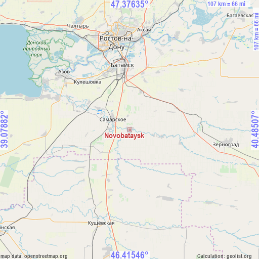
Novobataysk GPS coordinates[2]
46° 53' 53.016" North, 39° 46' 54.984" East
| Map corner | latitude | longitude |
|---|---|---|
| Upper-left | 47.37635°, | 39.07882° |
| Center: | 46.89806°, | 39.78194° |
| Lower-right: | 46.41546°, | 40.48507° |
| Map W x H: | 106.8×106.8 km | = 66.4×66.4mi |
| max Lat: | 73.50819° ⇑82.3% North |
| Novobataysk: | 46.89806° |
| min Lat: | ⇓17.7% South 41.28413° |
| min Long | Novobataysk | max Long |
| -179.12198° | 39.78194° | 179.35046° |
| W 31.4%⇐ | ⇒68.6% E |
Elevation
Elevation of Novobataysk is 13 m = 43 ft, and this is 189.6 m = 622 ft below average elevation for this country.
| Max E: |
2518 m = 8261 ft | 94.8% |
| Avg. | 202.6 m = 665 ft | |
| Novobataysk | 13 m = 43 ft | |
Min E: |
-28 m = -92 ft | 5.2% |
See also: Russia elevation on elevation.city.
Geographical zone
Novobataysk is located in North temperate zone (between Tropic of Cancer and the Arctic Circle). Distance of this North polar circle is 2186.6 km =1358.7 mi to North.| Distance of | km | miles | from Novobataysk |
|---|---|---|---|
| North Pole | 4792.5 | 2977.9 | to North |
| Arctic Circle | 2186.6 | 1358.7 | to North |
| Tropic Cancer | 2608.7 | 1621 | to South |
| Equator | 5214.6 | 3240.2 | to South |


Nearby cities:
15 places around Novobataysk: (largest is in red/bold)
• Aksay
40.6 km =25.2 mi,  9°
9°
• Azov
36.2 km =22.5 mi,  310°
310°
• Bataysk
27 km =16.8 mi,  355°
355°
• Imeni Chkalova
42.7 km =26.5 mi, 356°
• Kagal’nitskaya
27.8 km =17.3 mi,  94°
94°
• Kirovskaya
21.4 km =13.3 mi,  66°
66°
• Krasnoye
24.4 km =15.2 mi,  222°
222°
• Kuleshovka
26.2 km =16.3 mi,  319°
319°
• Kushchëvskaya
39.3 km =24.4 mi,  196°
196°
• Ol’ginskaya
34.6 km =21.5 mi,  21°
21°
• Peshkovo
32.7 km =20.3 mi,  294°
294°
• Rostov-na-Donu
37.3 km =23.2 mi,  353°
353°
• Samarskoye
8.3 km =5.2 mi,  301°
301°
• Starocherkasskaya
42.9 km =26.7 mi,  27°
27°
• Zernograd
40.4 km =25.1 mi,  98°
98°
Sources, notices
• [Note1] Compared only with cities in Russia existing in our database
• [Src1] Map data: © OpenStreetMap contributors (CC-BY-SA)
• [Src2] Other city data from geonames.org with taken over terms of usage.
• [Src3] Geographical zone / Annual Mean Temperature by Robert A. Rohde @ Wikipedia
