Igra geodata
Igra (Udmurtiya Republic) is a seat of a second-order administrative division; located in Russia in Europe/Samara (GMT+4) time zone. With population of 22,033 people, there are 816 cities with bigger population in this country. Compared to other cities in Russia, 80.2% of cities are located further ↓South; 64.9% of cities are located further ←West and 62.9% of cities have lower elevation than Igra. Note1


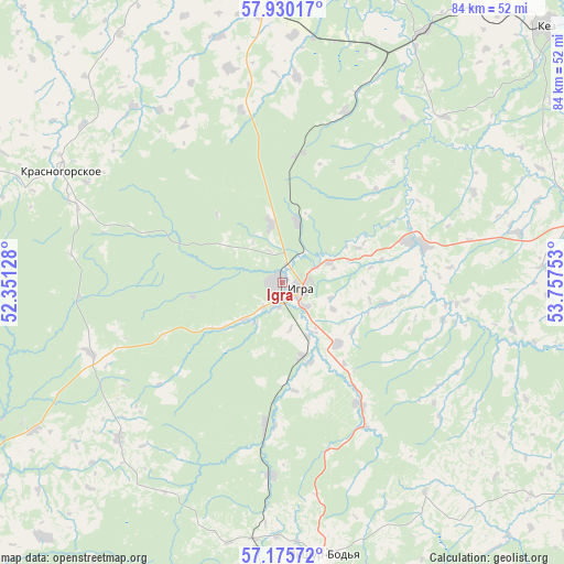
Igra GPS coordinates[2]
57° 33' 17.64" North, 53° 3' 15.84" East
| Map corner | latitude | longitude |
|---|---|---|
| Upper-left | 57.93017°, | 52.35128° |
| Center: | 57.5549°, | 53.0544° |
| Lower-right: | 57.17572°, | 53.75753° |
| Map W x H: | 83.9×83.9 km | = 52.1×52.1mi |
| max Lat: | 73.50819° ⇑19.8% North |
| Igra: | 57.5549° |
| min Lat: | ⇓80.2% South 41.28413° |
| min Long | Igra | max Long |
| -179.12198° | 53.0544° | 179.35046° |
| W 64.9%⇐ | ⇒35.1% E |
Elevation
Elevation of Igra is 176 m = 577 ft, and this is 26.6 m = 87 ft below average elevation for this country.
| Max E: |
2518 m = 8261 ft | 37.1% |
| Avg. | 202.6 m = 665 ft | |
| Igra | 176 m = 577 ft | |
Min E: |
-28 m = -92 ft | 62.9% |
See also: Russia elevation on elevation.city.
Geographical zone
Igra is located in North temperate zone (between Tropic of Cancer and the Arctic Circle). Distance of this North polar circle is 1001.7 km =622.4 mi to North.| Distance of | km | miles | from Igra |
|---|---|---|---|
| North Pole | 3607.6 | 2241.7 | to North |
| Arctic Circle | 1001.7 | 622.4 | to North |
| Tropic Cancer | 3793.6 | 2357.2 | to South |
| Equator | 6399.5 | 3976.5 | to South |


Nearby cities:
15 places around Igra: (largest is in red/bold)
• Balezino
47.2 km =29.3 mi,  357°
357°
• Debesy
46.2 km =28.7 mi,  76°
76°
• Fakel
8.6 km =5.3 mi,  348°
348°
• Glazov
69.1 km =42.9 mi,  340°
340°
• Izhevsk
78.9 km =49 mi,  173°
173°
• Kez
54.5 km =33.9 mi,  45°
45°
• Khokhryaki
72.9 km =45.3 mi, 167°
• Krasnogorskoye
37 km =23 mi,  296°
296°
• Pirogovo
86.4 km =53.7 mi,  176°
176°
• Selty
61.3 km =38.1 mi,  243°
243°
• Sharkan
56.6 km =35.2 mi,  120°
120°
• Uva
81.6 km =50.7 mi,  219°
219°
• Votkinsk
79.4 km =49.3 mi,  135°
135°
• Yukamenskoye
60.7 km =37.7 mi,  307°
307°
• Yunda
37.6 km =23.4 mi, 345°
Sources, notices
• [Note1] Compared only with cities in Russia existing in our database
• [Src1] Map data: © OpenStreetMap contributors (CC-BY-SA)
• [Src2] Other city data from geonames.org with taken over terms of usage.
• [Src3] Geographical zone / Annual Mean Temperature by Robert A. Rohde @ Wikipedia
