Selty geodata
Selty (Udmurtiya Republic) is a populated place; located in Russia in Europe/Samara (GMT+4) time zone. With population of 5,523 people, there are 2431 cities with bigger population in this country. Compared to other cities in Russia, 79.1% of cities are located further ↓South; 64% of cities are located further ←West and 53.1% of cities have higher elevation than Selty. Note1


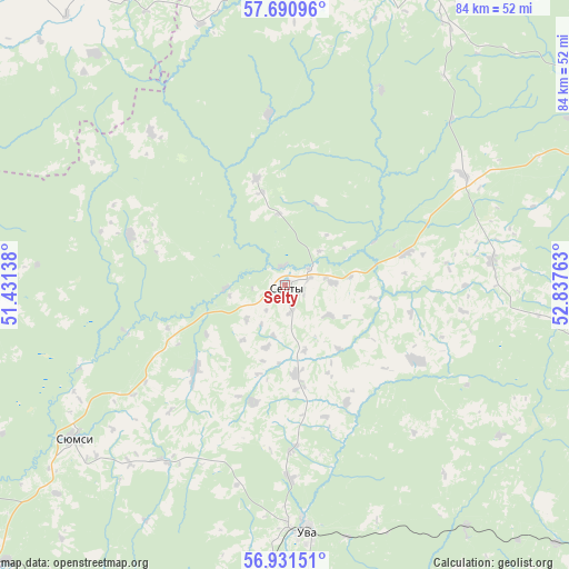
Selty GPS coordinates[2]
57° 18' 47.52" North, 52° 8' 4.2" East
| Map corner | latitude | longitude |
|---|---|---|
| Upper-left | 57.69096°, | 51.43138° |
| Center: | 57.3132°, | 52.1345° |
| Lower-right: | 56.93151°, | 52.83763° |
| Map W x H: | 84.4×84.4 km | = 52.4×52.4mi |
| max Lat: | 73.50819° ⇑20.9% North |
| Selty: | 57.3132° |
| min Lat: | ⇓79.1% South 41.28413° |
| min Long | Selty | max Long |
| -179.12198° | 52.1345° | 179.35046° |
| W 64%⇐ | ⇒36% E |
Elevation
Elevation of Selty is 138 m = 453 ft, and this is 64.6 m = 212 ft below average elevation for this country.
| Max E: |
2518 m = 8261 ft | 53.1% |
| Avg. | 202.6 m = 665 ft | |
| Selty | 138 m = 453 ft | |
Min E: |
-28 m = -92 ft | 46.9% |
See also: Russia elevation on elevation.city.
Geographical zone
Selty is located in North temperate zone (between Tropic of Cancer and the Arctic Circle). Distance of this North polar circle is 1028.5 km =639.1 mi to North.| Distance of | km | miles | from Selty |
|---|---|---|---|
| North Pole | 3634.4 | 2258.3 | to North |
| Arctic Circle | 1028.5 | 639.1 | to North |
| Tropic Cancer | 3766.7 | 2340.5 | to South |
| Equator | 6372.6 | 3959.7 | to South |


Nearby cities:
15 places around Selty: (largest is in red/bold)
• Balezino
90.6 km =56.3 mi,  35°
35°
• Fakel
63.9 km =39.7 mi,  56°
56°
• Igra
61.3 km =38.1 mi, 63°
• Izhevsk
82.7 km =51.4 mi,  128°
128°
• Khokhryaki
84.2 km =52.3 mi,  121°
121°
• Kil’mez’
76.5 km =47.5 mi,  237°
237°
• Krasnogorskoye
48.7 km =30.3 mi,  26°
26°
• Pirogovo
85.4 km =53.1 mi, 134°
• Pychas
92 km =57.2 mi,  168°
168°
• Syumsi
38.5 km =23.9 mi,  234°
234°
• Uni
62 km =38.5 mi,  321°
321°
• Uva
36 km =22.4 mi,  175°
175°
• Vavozh
61.1 km =38 mi,  191°
191°
• Yukamenskoye
64.2 km =39.9 mi,  5°
5°
• Yunda
77.8 km =48.3 mi, 35°
Sources, notices
• [Note1] Compared only with cities in Russia existing in our database
• [Src1] Map data: © OpenStreetMap contributors (CC-BY-SA)
• [Src2] Other city data from geonames.org with taken over terms of usage.
• [Src3] Geographical zone / Annual Mean Temperature by Robert A. Rohde @ Wikipedia
