Verkhniye Tatyshly geodata
Verkhniye Tatyshly (Bashkortostan Republic) is a populated place; located in Russia in Asia/Yekaterinburg (GMT+5) time zone. With population of 6,341 people, there are 2166 cities with bigger population in this country. Compared to other cities in Russia, 70.5% of cities are located further ↓South; 67.2% of cities are located further ←West and 56.3% of cities have lower elevation than Verkhniye Tatyshly. Note1


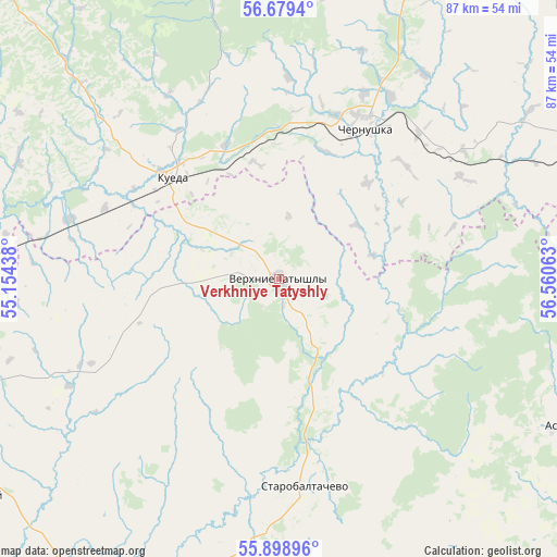
Verkhniye Tatyshly GPS coordinates[2]
56° 17' 28.212" North, 55° 51' 27" East
| Map corner | latitude | longitude |
|---|---|---|
| Upper-left | 56.6794°, | 55.15438° |
| Center: | 56.29117°, | 55.8575° |
| Lower-right: | 55.89896°, | 56.56063° |
| Map W x H: | 86.8×86.8 km | = 53.9×53.9mi |
| max Lat: | 73.50819° ⇑29.5% North |
| Verkhniye Tatyshly: | 56.29117° |
| min Lat: | ⇓70.5% South 41.28413° |
| min Long | Verkhniye Tatys | max Long |
| -179.12198° | 55.8575° | 179.35046° |
| W 67.2%⇐ | ⇒32.8% E |
Elevation
Elevation of Verkhniye Tatyshly is 159 m = 522 ft, and this is 43.6 m = 143 ft below average elevation for this country.
| Max E: |
2518 m = 8261 ft | 43.7% |
| Avg. | 202.6 m = 665 ft | |
| Verkhniye Tatyshly | 159 m = 522 ft | |
Min E: |
-28 m = -92 ft | 56.3% |
See also: Russia elevation on elevation.city.
Geographical zone
Verkhniye Tatyshly is located in North temperate zone (between Tropic of Cancer and the Arctic Circle). Distance of this North polar circle is 1142.2 km =709.7 mi to North.| Distance of | km | miles | from Verkhniye Tatyshly |
|---|---|---|---|
| North Pole | 3748.1 | 2329 | to North |
| Arctic Circle | 1142.2 | 709.7 | to North |
| Tropic Cancer | 3653.1 | 2269.9 | to South |
| Equator | 6259 | 3889.2 | to South |


Nearby cities:
15 places around Verkhniye Tatyshly: (largest is in red/bold)
• Amzya
91.1 km =56.6 mi,  266°
266°
• Askino
49.9 km =31 mi,  116°
116°
• Barda
72.7 km =45.2 mi,  347°
347°
• Burayevo
57.3 km =35.6 mi,  209°
209°
• Chernushka
27.5 km =17.1 mi,  29°
29°
• Kaltasy
74.5 km =46.3 mi,  241°
241°
• Karaidel’
82.6 km =51.3 mi,  127°
127°
• Karayar
97.9 km =60.8 mi, 132°
• Krasnokholmskiy
60.5 km =37.6 mi, 236°
• Kuyeda
22.7 km =14.1 mi,  313°
313°
• Maginsk
90.5 km =56.2 mi, 130°
• Sars
83.8 km =52.1 mi,  69°
69°
• Starobaltachevo
32.5 km =20.2 mi,  172°
172°
• Uinskoye
79.2 km =49.2 mi, 34°
• Yanaul
57 km =35.4 mi, 268°
Sources, notices
• [Note1] Compared only with cities in Russia existing in our database
• [Src1] Map data: © OpenStreetMap contributors (CC-BY-SA)
• [Src2] Other city data from geonames.org with taken over terms of usage.
• [Src3] Geographical zone / Annual Mean Temperature by Robert A. Rohde @ Wikipedia
