Karaidel’ geodata
Karaidel’ (Bashkortostan Republic) is a populated place; located in Russia in Asia/Yekaterinburg (GMT+5) time zone. With population of 5,184 people, there are 2568 cities with bigger population in this country. Compared to other cities in Russia, 64.1% of cities are located further ↓South; 68.5% of cities are located further ←West and 72.3% of cities have lower elevation than Karaidel’. Note1


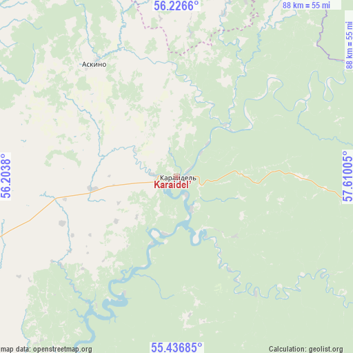
Karaidel’ GPS coordinates[2]
55° 50' 1.428" North, 56° 54' 24.912" East
| Map corner | latitude | longitude |
|---|---|---|
| Upper-left | 56.2266°, | 56.2038° |
| Center: | 55.83373°, | 56.90692° |
| Lower-right: | 55.43685°, | 57.61005° |
| Map W x H: | 87.8×87.8 km | = 54.6×54.6mi |
| max Lat: | 73.50819° ⇑35.9% North |
| Karaidel’: | 55.83373° |
| min Lat: | ⇓64.1% South 41.28413° |
| min Long | Karaidel’ | max Long |
| -179.12198° | 56.90692° | 179.35046° |
| W 68.5%⇐ | ⇒31.5% E |
Elevation
Elevation of Karaidel’ is 206 m = 676 ft, and this is 3.4 m = 11 ft above average elevation for this country.
| Max E: |
2518 m = 8261 ft | 27.7% |
| Karaidel’ | 206 m 676 ft | |
| Avg. | 202.6 m = 665 ft | |
Min E: |
-28 m = -92 ft | 72.3% |
See also: Russia elevation on elevation.city.
Geographical zone
Karaidel’ is located in North temperate zone (between Tropic of Cancer and the Arctic Circle). Distance of this North polar circle is 1193 km =741.3 mi to North.| Distance of | km | miles | from Karaidel’ |
|---|---|---|---|
| North Pole | 3798.9 | 2360.5 | to North |
| Arctic Circle | 1193 | 741.3 | to North |
| Tropic Cancer | 3602.2 | 2238.3 | to South |
| Equator | 6208.1 | 3857.5 | to South |


Nearby cities:
15 places around Karaidel’: (largest is in red/bold)
• Askino
35.1 km =21.8 mi,  324°
324°
• Bedeyeva Polyana
65.4 km =40.6 mi,  209°
209°
• Chernushka
90.8 km =56.4 mi,  325°
325°
• Duvan
64.2 km =39.9 mi,  103°
103°
• Karayar
16.6 km =10.3 mi,  153°
153°
• Krasnaya Gorka
72.5 km =45 mi,  192°
192°
• Krasnyy Klyuch
52.3 km =32.5 mi,  197°
197°
• Maginsk
8.6 km =5.3 mi, 154°
• Mesyagutovo
90.9 km =56.5 mi,  111°
111°
• Pavlovka
51 km =31.7 mi, 205°
• Sarana
87.7 km =54.5 mi,  35°
35°
• Sars
80.9 km =50.3 mi,  10°
10°
• Starobaltachevo
63.8 km =39.6 mi,  287°
287°
• Verkhniye Tatyshly
82.6 km =51.3 mi,  307°
307°
• Yazykovo
83.8 km =52.1 mi,  215°
215°
Sources, notices
• [Note1] Compared only with cities in Russia existing in our database
• [Src1] Map data: © OpenStreetMap contributors (CC-BY-SA)
• [Src2] Other city data from geonames.org with taken over terms of usage.
• [Src3] Geographical zone / Annual Mean Temperature by Robert A. Rohde @ Wikipedia
