Kaltasy geodata
Kaltasy (Bashkortostan Republic) is a populated place; located in Russia in Asia/Yekaterinburg (GMT+5) time zone. With population of 4,454 people, there are 2886 cities with bigger population in this country. Compared to other cities in Russia, 66.2% of cities are located further ↓South; 66.3% of cities are located further ←West and 59.2% of cities have higher elevation than Kaltasy. Note1


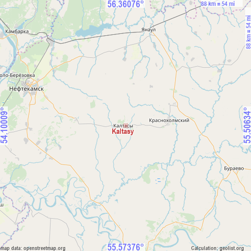
Kaltasy GPS coordinates[2]
55° 58' 9.336" North, 54° 48' 11.556" East
| Map corner | latitude | longitude |
|---|---|---|
| Upper-left | 56.36076°, | 54.10009° |
| Center: | 55.96926°, | 54.80321° |
| Lower-right: | 55.57376°, | 55.50634° |
| Map W x H: | 87.5×87.5 km | = 54.4×54.4mi |
| max Lat: | 73.50819° ⇑33.8% North |
| Kaltasy: | 55.96926° |
| min Lat: | ⇓66.2% South 41.28413° |
| min Long | Kaltasy | max Long |
| -179.12198° | 54.80321° | 179.35046° |
| W 66.3%⇐ | ⇒33.7% E |
Elevation
Elevation of Kaltasy is 126 m = 413 ft, and this is 76.6 m = 251 ft below average elevation for this country.
| Max E: |
2518 m = 8261 ft | 59.2% |
| Avg. | 202.6 m = 665 ft | |
| Kaltasy | 126 m = 413 ft | |
Min E: |
-28 m = -92 ft | 40.8% |
See also: Russia elevation on elevation.city.
Geographical zone
Kaltasy is located in North temperate zone (between Tropic of Cancer and the Arctic Circle). Distance of this North polar circle is 1178 km =732 mi to North.| Distance of | km | miles | from Kaltasy |
|---|---|---|---|
| North Pole | 3783.9 | 2351.2 | to North |
| Arctic Circle | 1178 | 732 | to North |
| Tropic Cancer | 3617.3 | 2247.7 | to South |
| Equator | 6223.2 | 3866.9 | to South |


Nearby cities:
15 places around Kaltasy: (largest is in red/bold)
• Agidel’
54.5 km =33.9 mi,  262°
262°
• Aktanysh
52.7 km =32.7 mi,  238°
238°
• Amzya
39.3 km =24.4 mi,  318°
318°
• Burayevo
40.3 km =25 mi,  110°
110°
• Dyurtyuli
53.3 km =33.1 mi,  175°
175°
• Kama
57.7 km =35.9 mi,  310°
310°
• Kambarka
49.7 km =30.9 mi, 311°
• Karakulino
68.4 km =42.5 mi,  273°
273°
• Krasnokholmskiy
15.3 km =9.5 mi,  82°
82°
• Neftekamsk
36.1 km =22.4 mi,  292°
292°
• Nikolo-Berëzovka
43.7 km =27.2 mi, 293°
• Semiletka
68.7 km =42.7 mi,  189°
189°
• Starobaltachevo
70.1 km =43.6 mi,  87°
87°
• Verkhneyarkeyevo
65.3 km =40.6 mi,  207°
207°
• Yanaul
35 km =21.7 mi,  13°
13°
Sources, notices
• [Note1] Compared only with cities in Russia existing in our database
• [Src1] Map data: © OpenStreetMap contributors (CC-BY-SA)
• [Src2] Other city data from geonames.org with taken over terms of usage.
• [Src3] Geographical zone / Annual Mean Temperature by Robert A. Rohde @ Wikipedia
