Utamysh geodata
Utamysh (Dagestan) is a populated place; located in Russia in Europe/Moscow (GMT+3) time zone. With population of 3,714 people, there are 3259 cities with bigger population in this country. Compared to other cities in Russia, 99% of cities are located further ↑North; 58.2% of cities are located further ←West and 85.3% of cities have lower elevation than Utamysh. Note1


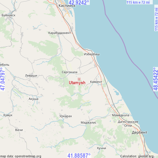
Utamysh GPS coordinates[2]
42° 24' 25.848" North, 47° 45' 3.924" East
| Map corner | latitude | longitude |
|---|---|---|
| Upper-left | 42.9242°, | 47.04797° |
| Center: | 42.40718°, | 47.75109° |
| Lower-right: | 41.88587°, | 48.45422° |
| Map W x H: | 115.5×115.5 km | = 71.8×71.8mi |
| max Lat: | 73.50819° ⇑99% North |
| Utamysh: | 42.40718° |
| min Lat: | ⇓1% South 41.28413° |
| min Long | Utamysh | max Long |
| -179.12198° | 47.75109° | 179.35046° |
| W 58.2%⇐ | ⇒41.8% E |
Elevation
Elevation of Utamysh is 327 m = 1073 ft, and this is 124.4 m = 408 ft above average elevation for this country.
| Max E: |
2518 m = 8261 ft | 14.7% |
| Utamysh | 327 m 1073 ft | |
| Avg. | 202.6 m = 665 ft | |
Min E: |
-28 m = -92 ft | 85.3% |
See also: Russia elevation on elevation.city.
Geographical zone
Utamysh is located in North temperate zone (between Tropic of Cancer and the Arctic Circle). Distance of this Northern Tropic circle is 2109.3 km =1310.7 mi to South.| Distance of | km | miles | from Utamysh |
|---|---|---|---|
| North Pole | 5291.8 | 3288.2 | to North |
| Arctic Circle | 2685.9 | 1668.9 | to North |
| Tropic Cancer | 2109.3 | 1310.7 | to South |
| Equator | 4715.2 | 2929.9 | to South |


Nearby cities:
15 places around Utamysh: (largest is in red/bold)
• Achisu
27.8 km =17.3 mi,  348°
348°
• Druzhba
27.6 km =17.1 mi,  131°
131°
• Gerga
18.7 km =11.6 mi,  111°
111°
• Gubden
23.5 km =14.6 mi,  319°
319°
• Gurbuki
25.8 km =16 mi,  331°
331°
• Izberbash
20.3 km =12.6 mi,  27°
27°
• Kayakent
12.7 km =7.9 mi,  100°
100°
• Kishcha
29.2 km =18.1 mi,  208°
208°
• Mugi
29.7 km =18.5 mi,  246°
246°
• Myurego
4.8 km =3 mi,  274°
274°
• Novokayakent
19.4 km =12.1 mi,  94°
94°
• Sergokala
9.1 km =5.7 mi,  305°
305°
• Ulluaya
31.1 km =19.3 mi,  263°
263°
• Ullubiyaul
21.3 km =13.2 mi, 352°
• Urkarakh
28.9 km =18 mi,  200°
200°
Sources, notices
• [Note1] Compared only with cities in Russia existing in our database
• [Src1] Map data: © OpenStreetMap contributors (CC-BY-SA)
• [Src2] Other city data from geonames.org with taken over terms of usage.
• [Src3] Geographical zone / Annual Mean Temperature by Robert A. Rohde @ Wikipedia
