Kayakent geodata
Kayakent (Dagestan) is a populated place; located in Russia in Europe/Moscow (GMT+3) time zone. With population of 11,805 people, there are 1300 cities with bigger population in this country. Compared to other cities in Russia, 99.1% of cities are located further ↑North; 58.5% of cities are located further ←West and 56.3% of cities have lower elevation than Kayakent. Note1


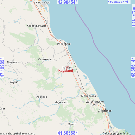
Kayakent GPS coordinates[2]
42° 23' 14.496" North, 47° 54' 10.836" East
| Map corner | latitude | longitude |
|---|---|---|
| Upper-left | 42.90454°, | 47.19989° |
| Center: | 42.38736°, | 47.90301° |
| Lower-right: | 41.86588°, | 48.60614° |
| Map W x H: | 115.5×115.5 km | = 71.8×71.8mi |
| max Lat: | 73.50819° ⇑99.1% North |
| Kayakent: | 42.38736° |
| min Lat: | ⇓0.9% South 41.28413° |
| min Long | Kayakent | max Long |
| -179.12198° | 47.90301° | 179.35046° |
| W 58.5%⇐ | ⇒41.5% E |
Elevation
Elevation of Kayakent is 159 m = 522 ft, and this is 43.6 m = 143 ft below average elevation for this country.
| Max E: |
2518 m = 8261 ft | 43.7% |
| Avg. | 202.6 m = 665 ft | |
| Kayakent | 159 m = 522 ft | |
Min E: |
-28 m = -92 ft | 56.3% |
See also: Russia elevation on elevation.city.
Geographical zone
Kayakent is located in North temperate zone (between Tropic of Cancer and the Arctic Circle). Distance of this Northern Tropic circle is 2107.1 km =1309.3 mi to South.| Distance of | km | miles | from Kayakent |
|---|---|---|---|
| North Pole | 5294 | 3289.5 | to North |
| Arctic Circle | 2688.1 | 1670.3 | to North |
| Tropic Cancer | 2107.1 | 1309.3 | to South |
| Equator | 4713 | 2928.5 | to South |


Nearby cities:
15 places around Kayakent: (largest is in red/bold)
• Achisu
34.5 km =21.4 mi,  328°
328°
• Druzhba
18.1 km =11.2 mi,  153°
153°
• Gedzhukh
31.8 km =19.8 mi,  155°
155°
• Gerga
6.7 km =4.2 mi,  132°
132°
• Gubden
34.2 km =21.3 mi,  306°
306°
• Izberbash
20.5 km =12.7 mi,  351°
351°
• Madzhalis
30.1 km =18.7 mi,  190°
190°
• Mamedkala
30.1 km =18.7 mi,  144°
144°
• Myurego
17.4 km =10.8 mi,  278°
278°
• Novokayakent
6.9 km =4.3 mi,  84°
84°
• Sergokala
21.2 km =13.2 mi,  290°
290°
• Ullubiyaul
27.8 km =17.3 mi, 326°
• Urkarakh
33.5 km =20.8 mi,  221°
221°
• Utamysh
12.7 km =7.9 mi, 280°
• Velikent
25.8 km =16 mi, 149°
Sources, notices
• [Note1] Compared only with cities in Russia existing in our database
• [Src1] Map data: © OpenStreetMap contributors (CC-BY-SA)
• [Src2] Other city data from geonames.org with taken over terms of usage.
• [Src3] Geographical zone / Annual Mean Temperature by Robert A. Rohde @ Wikipedia
