Myurego geodata
Myurego (Dagestan) is a populated place; located in Russia in Europe/Moscow (GMT+3) time zone. With population of 4,548 people, there are 2849 cities with bigger population in this country. Compared to other cities in Russia, 99% of cities are located further ↑North; 58.1% of cities are located further ←West and 91.9% of cities have lower elevation than Myurego. Note1


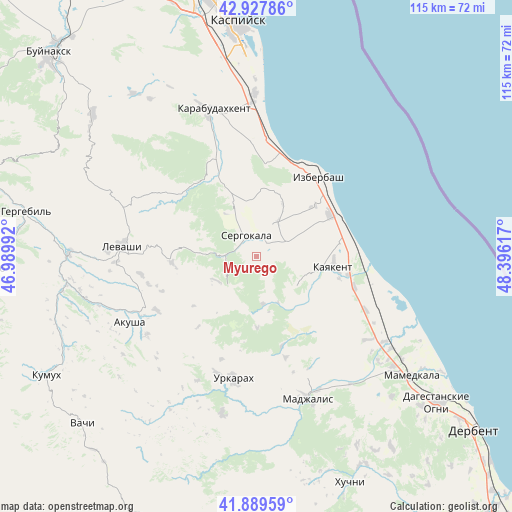
Myurego GPS coordinates[2]
42° 24' 39.132" North, 47° 41' 34.944" East
| Map corner | latitude | longitude |
|---|---|---|
| Upper-left | 42.92786°, | 46.98992° |
| Center: | 42.41087°, | 47.69304° |
| Lower-right: | 41.88959°, | 48.39617° |
| Map W x H: | 115.4×115.4 km | = 71.7×71.7mi |
| max Lat: | 73.50819° ⇑99% North |
| Myurego: | 42.41087° |
| min Lat: | ⇓1% South 41.28413° |
| min Long | Myurego | max Long |
| -179.12198° | 47.69304° | 179.35046° |
| W 58.1%⇐ | ⇒41.9% E |
Elevation
Elevation of Myurego is 502 m = 1647 ft, and this is 299.4 m = 982 ft above average elevation for this country.
| Max E: |
2518 m = 8261 ft | 8.1% |
| Myurego | 502 m 1647 ft | |
| Avg. | 202.6 m = 665 ft | |
Min E: |
-28 m = -92 ft | 91.9% |
See also: Russia elevation on elevation.city.
Geographical zone
Myurego is located in North temperate zone (between Tropic of Cancer and the Arctic Circle). Distance of this Northern Tropic circle is 2109.7 km =1310.9 mi to South.| Distance of | km | miles | from Myurego |
|---|---|---|---|
| North Pole | 5291.4 | 3287.9 | to North |
| Arctic Circle | 2685.5 | 1668.7 | to North |
| Tropic Cancer | 2109.7 | 1310.9 | to South |
| Equator | 4715.6 | 2930.1 | to South |


Nearby cities:
15 places around Myurego: (largest is in red/bold)
• Achisu
26.8 km =16.7 mi,  358°
358°
• Gerga
23.3 km =14.5 mi,  107°
107°
• Gubden
20.4 km =12.7 mi,  329°
329°
• Gurbuki
23.5 km =14.6 mi,  341°
341°
• Izberbash
22.6 km =14 mi,  38°
38°
• Kayakent
17.4 km =10.8 mi,  98°
98°
• Kishcha
27.6 km =17.1 mi,  199°
199°
• Mugi
25.6 km =15.9 mi,  241°
241°
• Novokayakent
24.1 km =15 mi,  94°
94°
• Sergokala
5.5 km =3.4 mi, 331°
• Ulluaya
26.5 km =16.5 mi,  261°
261°
• Ullubiyaul
20.8 km =12.9 mi,  5°
5°
• Urkarakh
28 km =17.4 mi,  190°
190°
• Usisha
30.4 km =18.9 mi,  234°
234°
• Utamysh
4.8 km =3 mi, 94°
Sources, notices
• [Note1] Compared only with cities in Russia existing in our database
• [Src1] Map data: © OpenStreetMap contributors (CC-BY-SA)
• [Src2] Other city data from geonames.org with taken over terms of usage.
• [Src3] Geographical zone / Annual Mean Temperature by Robert A. Rohde @ Wikipedia
