Gurbuki geodata
Gurbuki (Dagestan) is a populated place; located in Russia in Europe/Moscow (GMT+3) time zone. With population of 4,592 people, there are 2827 cities with bigger population in this country. Compared to other cities in Russia, 98.7% of cities are located further ↑North; 57.8% of cities are located further ←West and 89.3% of cities have lower elevation than Gurbuki. Note1


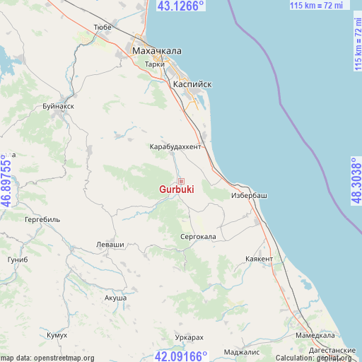
Gurbuki GPS coordinates[2]
42° 36' 40.608" North, 47° 36' 2.412" East
| Map corner | latitude | longitude |
|---|---|---|
| Upper-left | 43.1266°, | 46.89755° |
| Center: | 42.61128°, | 47.60067° |
| Lower-right: | 42.09166°, | 48.3038° |
| Map W x H: | 115.1×115.1 km | = 71.5×71.5mi |
| max Lat: | 73.50819° ⇑98.7% North |
| Gurbuki: | 42.61128° |
| min Lat: | ⇓1.3% South 41.28413° |
| min Long | Gurbuki | max Long |
| -179.12198° | 47.60067° | 179.35046° |
| W 57.8%⇐ | ⇒42.2% E |
Elevation
Elevation of Gurbuki is 434 m = 1424 ft, and this is 231.4 m = 759 ft above average elevation for this country.
| Max E: |
2518 m = 8261 ft | 10.7% |
| Gurbuki | 434 m 1424 ft | |
| Avg. | 202.6 m = 665 ft | |
Min E: |
-28 m = -92 ft | 89.3% |
See also: Russia elevation on elevation.city.
Geographical zone
Gurbuki is located in North temperate zone (between Tropic of Cancer and the Arctic Circle). Distance of this Northern Tropic circle is 2132 km =1324.8 mi to South.| Distance of | km | miles | from Gurbuki |
|---|---|---|---|
| North Pole | 5269.1 | 3274.1 | to North |
| Arctic Circle | 2663.2 | 1654.8 | to North |
| Tropic Cancer | 2132 | 1324.8 | to South |
| Equator | 4737.9 | 2944 | to South |


Nearby cities:
15 places around Gurbuki: (largest is in red/bold)
• Achisu
8.1 km =5 mi,  56°
56°
• Dorgeli
25.8 km =16 mi,  283°
283°
• Gubden
5.6 km =3.5 mi,  210°
210°
• Izberbash
22.1 km =13.7 mi,  102°
102°
• Karabudakhkent
11.2 km =7 mi,  345°
345°
• Karamakhi
27.9 km =17.3 mi,  271°
271°
• Kaspiysk
30.2 km =18.8 mi,  5°
5°
• Manas
14.4 km =8.9 mi,  26°
26°
• Manaskent
16.1 km =10 mi, 27°
• Myurego
23.5 km =14.6 mi,  161°
161°
• Paraul
24.8 km =15.4 mi,  305°
305°
• Sergokala
18.1 km =11.2 mi, 164°
• Ullubiyaul
9.8 km =6.1 mi, 99°
• Urma
27 km =16.8 mi,  252°
252°
• Utamysh
25.8 km =16 mi,  151°
151°
Sources, notices
• [Note1] Compared only with cities in Russia existing in our database
• [Src1] Map data: © OpenStreetMap contributors (CC-BY-SA)
• [Src2] Other city data from geonames.org with taken over terms of usage.
• [Src3] Geographical zone / Annual Mean Temperature by Robert A. Rohde @ Wikipedia
