Izberbash geodata
Izberbash (Dagestan) is a populated place; located in Russia in Europe/Moscow (GMT+3) time zone. With population of 42,121 people, there are 499 cities with bigger population in this country. Compared to other cities in Russia, 98.8% of cities are located further ↑North; 58.4% of cities are located further ←West and 99% of cities have higher elevation than Izberbash. Note1


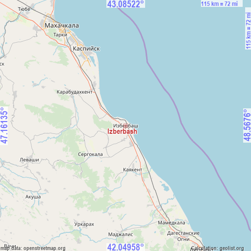
Izberbash GPS coordinates[2]
42° 34' 10.38" North, 47° 51' 52.092" East
| Map corner | latitude | longitude |
|---|---|---|
| Upper-left | 43.08522°, | 47.16135° |
| Center: | 42.56955°, | 47.86447° |
| Lower-right: | 42.04958°, | 48.5676° |
| Map W x H: | 115.2×115.2 km | = 71.6×71.6mi |
| max Lat: | 73.50819° ⇑98.8% North |
| Izberbash: | 42.56955° |
| min Lat: | ⇓1.2% South 41.28413° |
| min Long | Izberbash | max Long |
| -179.12198° | 47.86447° | 179.35046° |
| W 58.4%⇐ | ⇒41.6% E |
Elevation
Elevation of Izberbash is -5 m = -16 ft, and this is 207.6 m = 681 ft below average elevation for this country.
| Max E: |
2518 m = 8261 ft | 99% |
| Avg. | 202.6 m = 665 ft | |
| Izberbash | -5 m = -16 ft | |
Min E: |
-28 m = -92 ft | 1% |
See also: Izberbash elevation on elevation.city.
Geographical zone
Izberbash is located in North temperate zone (between Tropic of Cancer and the Arctic Circle). Distance of this Northern Tropic circle is 2127.4 km =1321.9 mi to South.| Distance of | km | miles | from Izberbash |
|---|---|---|---|
| North Pole | 5273.8 | 3277 | to North |
| Arctic Circle | 2667.9 | 1657.8 | to North |
| Tropic Cancer | 2127.4 | 1321.9 | to South |
| Equator | 4733.3 | 2941.1 | to South |


Nearby cities:
15 places around Izberbash: (largest is in red/bold)
• Achisu
17.5 km =10.9 mi,  301°
301°
• Druzhba
38.1 km =23.7 mi,  162°
162°
• Gerga
26.1 km =16.2 mi, 161°
• Gubden
24.5 km =15.2 mi,  269°
269°
• Gurbuki
22.1 km =13.7 mi,  282°
282°
• Karabudakhkent
28.8 km =17.9 mi, 302°
• Kaspiysk
39.3 km =24.4 mi,  332°
332°
• Kayakent
20.5 km =12.7 mi,  171°
171°
• Manas
23.2 km =14.4 mi,  319°
319°
• Manaskent
23.7 km =14.7 mi, 323°
• Myurego
22.6 km =14 mi,  218°
218°
• Novokayakent
22 km =13.7 mi,  152°
152°
• Sergokala
21 km =13 mi,  232°
232°
• Ullubiyaul
12.4 km =7.7 mi, 284°
• Utamysh
20.3 km =12.6 mi,  207°
207°
Sources, notices
• [Note1] Compared only with cities in Russia existing in our database
• [Src1] Map data: © OpenStreetMap contributors (CC-BY-SA)
• [Src2] Other city data from geonames.org with taken over terms of usage.
• [Src3] Geographical zone / Annual Mean Temperature by Robert A. Rohde @ Wikipedia
