Gerga geodata
Gerga (Dagestan) is a populated place; located in Russia in Europe/Moscow (GMT+3) time zone. With population of 3,778 people, there are 3229 cities with bigger population in this country. Compared to other cities in Russia, 99.2% of cities are located further ↑North; 58.8% of cities are located further ←West and 89.2% of cities have higher elevation than Gerga. Note1


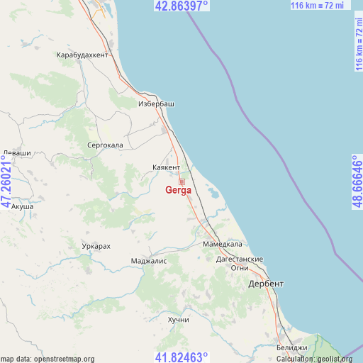
Gerga GPS coordinates[2]
42° 20' 47.22" North, 47° 57' 47.988" East
| Map corner | latitude | longitude |
|---|---|---|
| Upper-left | 42.86397°, | 47.26021° |
| Center: | 42.34645°, | 47.96333° |
| Lower-right: | 41.82463°, | 48.66646° |
| Map W x H: | 115.6×115.6 km | = 71.8×71.8mi |
| max Lat: | 73.50819° ⇑99.2% North |
| Gerga: | 42.34645° |
| min Lat: | ⇓0.8% South 41.28413° |
| min Long | Gerga | max Long |
| -179.12198° | 47.96333° | 179.35046° |
| W 58.8%⇐ | ⇒41.2% E |
Elevation
Elevation of Gerga is 31 m = 102 ft, and this is 171.6 m = 563 ft below average elevation for this country.
| Max E: |
2518 m = 8261 ft | 89.2% |
| Avg. | 202.6 m = 665 ft | |
| Gerga | 31 m = 102 ft | |
Min E: |
-28 m = -92 ft | 10.8% |
See also: Russia elevation on elevation.city.
Geographical zone
Gerga is located in North temperate zone (between Tropic of Cancer and the Arctic Circle). Distance of this Northern Tropic circle is 2102.6 km =1306.5 mi to South.| Distance of | km | miles | from Gerga |
|---|---|---|---|
| North Pole | 5298.6 | 3292.4 | to North |
| Arctic Circle | 2692.7 | 1673.2 | to North |
| Tropic Cancer | 2102.6 | 1306.5 | to South |
| Equator | 4708.5 | 2925.7 | to South |


Nearby cities:
15 places around Gerga: (largest is in red/bold)
• Chinar
30.4 km =18.9 mi,  150°
150°
• Dagestanskiye Ogni
31.8 km =19.8 mi,  143°
143°
• Druzhba
12 km =7.5 mi,  164°
164°
• Gedzhukh
25.7 km =16 mi, 161°
• Izberbash
26.1 km =16.2 mi,  341°
341°
• Kayakent
6.7 km =4.2 mi,  312°
312°
• Madzhalis
27.2 km =16.9 mi,  203°
203°
• Mamedkala
23.6 km =14.7 mi, 147°
• Myurego
23.3 km =14.5 mi,  287°
287°
• Novokayakent
5.6 km =3.5 mi,  19°
19°
• Sergokala
27.6 km =17.1 mi,  295°
295°
• Ullubiyaul
34.3 km =21.3 mi,  324°
324°
• Urkarakh
34.1 km =21.2 mi,  233°
233°
• Utamysh
18.7 km =11.6 mi, 291°
• Velikent
19.5 km =12.1 mi, 154°
Sources, notices
• [Note1] Compared only with cities in Russia existing in our database
• [Src1] Map data: © OpenStreetMap contributors (CC-BY-SA)
• [Src2] Other city data from geonames.org with taken over terms of usage.
• [Src3] Geographical zone / Annual Mean Temperature by Robert A. Rohde @ Wikipedia
