Gubden geodata
Gubden (Dagestan) is a populated place; located in Russia in Europe/Moscow (GMT+3) time zone. With population of 7,997 people, there are 1798 cities with bigger population in this country. Compared to other cities in Russia, 98.8% of cities are located further ↑North; 57.6% of cities are located further ←West and 94.1% of cities have lower elevation than Gubden. Note1


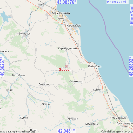
Gubden GPS coordinates[2]
42° 34' 5.088" North, 47° 33' 56.844" East
| Map corner | latitude | longitude |
|---|---|---|
| Upper-left | 43.08376°, | 46.86267° |
| Center: | 42.56808°, | 47.56579° |
| Lower-right: | 42.0481°, | 48.26892° |
| Map W x H: | 115.2×115.2 km | = 71.6×71.6mi |
| max Lat: | 73.50819° ⇑98.8% North |
| Gubden: | 42.56808° |
| min Lat: | ⇓1.2% South 41.28413° |
| min Long | Gubden | max Long |
| -179.12198° | 47.56579° | 179.35046° |
| W 57.6%⇐ | ⇒42.4% E |
Elevation
Elevation of Gubden is 589 m = 1932 ft, and this is 386.4 m = 1268 ft above average elevation for this country.
| Max E: |
2518 m = 8261 ft | 5.9% |
| Gubden | 589 m 1932 ft | |
| Avg. | 202.6 m = 665 ft | |
Min E: |
-28 m = -92 ft | 94.1% |
See also: Russia elevation on elevation.city.
Geographical zone
Gubden is located in North temperate zone (between Tropic of Cancer and the Arctic Circle). Distance of this Northern Tropic circle is 2127.2 km =1321.8 mi to South.| Distance of | km | miles | from Gubden |
|---|---|---|---|
| North Pole | 5273.9 | 3277 | to North |
| Arctic Circle | 2668 | 1657.8 | to North |
| Tropic Cancer | 2127.2 | 1321.8 | to South |
| Equator | 4733.1 | 2941 | to South |


Nearby cities:
15 places around Gubden: (largest is in red/bold)
• Achisu
13.4 km =8.3 mi,  45°
45°
• Dorgeli
24.8 km =15.4 mi,  296°
296°
• Gurbuki
5.6 km =3.5 mi,  30°
30°
• Izberbash
24.5 km =15.2 mi,  89°
89°
• Karabudakhkent
15.6 km =9.7 mi,  0°
0°
• Karamakhi
25.7 km =16 mi,  282°
282°
• Levashi
25.2 km =15.7 mi,  232°
232°
• Manas
20 km =12.4 mi, 27°
• Manaskent
21.7 km =13.5 mi, 28°
• Myurego
20.4 km =12.7 mi,  149°
149°
• Paraul
25.9 km =16.1 mi,  318°
318°
• Sergokala
14.8 km =9.2 mi, 148°
• Ullubiyaul
12.9 km =8 mi,  75°
75°
• Urma
23.1 km =14.4 mi,  261°
261°
• Utamysh
23.5 km =14.6 mi,  139°
139°
Sources, notices
• [Note1] Compared only with cities in Russia existing in our database
• [Src1] Map data: © OpenStreetMap contributors (CC-BY-SA)
• [Src2] Other city data from geonames.org with taken over terms of usage.
• [Src3] Geographical zone / Annual Mean Temperature by Robert A. Rohde @ Wikipedia
