Tselina geodata
Tselina (Rostov) is a seat of a second-order administrative division; located in Russia in Europe/Moscow (GMT+3) time zone. With population of 11,075 people, there are 1366 cities with bigger population in this country. Compared to other cities in Russia, 83% of cities are located further ↑North; 63% of cities are located further →East and 67.7% of cities have higher elevation than Tselina. Note1


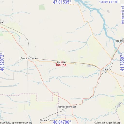
Tselina GPS coordinates[2]
46° 32' 1.716" North, 41° 1' 58.224" East
| Map corner | latitude | longitude |
|---|---|---|
| Upper-left | 47.01535°, | 40.32972° |
| Center: | 46.53381°, | 41.03284° |
| Lower-right: | 46.04796°, | 41.73597° |
| Map W x H: | 107.6×107.6 km | = 66.9×66.9mi |
| max Lat: | 73.50819° ⇑83% North |
| Tselina: | 46.53381° |
| min Lat: | ⇓17% South 41.28413° |
| min Long | Tselina | max Long |
| -179.12198° | 41.03284° | 179.35046° |
| W 37%⇐ | ⇒63% E |
Elevation
Elevation of Tselina is 108 m = 354 ft, and this is 94.6 m = 310 ft below average elevation for this country.
| Max E: |
2518 m = 8261 ft | 67.7% |
| Avg. | 202.6 m = 665 ft | |
| Tselina | 108 m = 354 ft | |
Min E: |
-28 m = -92 ft | 32.3% |
See also: Russia elevation on elevation.city.
Geographical zone
Tselina is located in North temperate zone (between Tropic of Cancer and the Arctic Circle). Distance of this North polar circle is 2227.1 km =1383.9 mi to North.| Distance of | km | miles | from Tselina |
|---|---|---|---|
| North Pole | 4833 | 3003.1 | to North |
| Arctic Circle | 2227.1 | 1383.9 | to North |
| Tropic Cancer | 2568.2 | 1595.8 | to South |
| Equator | 5174.1 | 3215 | to South |


Nearby cities:
15 places around Tselina: (largest is in red/bold)
• Belaya Glina
52.3 km =32.5 mi,  194°
194°
• Gigant
23.8 km =14.8 mi,  97°
97°
• Krasnaya Polyana
59 km =36.7 mi,  142°
142°
• Letnik
60.8 km =37.8 mi,  162°
162°
• Mechetinskaya
51.3 km =31.9 mi,  300°
300°
• Novopokrovskaya
69.6 km =43.2 mi,  201°
201°
• Novyy Yegorlyk
66.1 km =41.1 mi, 103°
• Peschanokopskoye
37.8 km =23.5 mi,  174°
174°
• Proletarsk
56.3 km =35 mi,  70°
70°
• Rassvet
39.7 km =24.7 mi,  327°
327°
• Sal’sk
39.5 km =24.5 mi, 99°
• Sandata
62.8 km =39 mi,  117°
117°
• Vesëlyy
66 km =41 mi,  340°
340°
• Yegorlykskaya
29 km =18 mi,  277°
277°
• Zernograd
65.2 km =40.5 mi, 302°
Sources, notices
• [Note1] Compared only with cities in Russia existing in our database
• [Src1] Map data: © OpenStreetMap contributors (CC-BY-SA)
• [Src2] Other city data from geonames.org with taken over terms of usage.
• [Src3] Geographical zone / Annual Mean Temperature by Robert A. Rohde @ Wikipedia
