Syrtych geodata
Syrtych (Dagestan) is a populated place; located in Russia in Europe/Moscow (GMT+3) time zone. With population of 4,185 people, there are 3010 cities with bigger population in this country. Compared to other cities in Russia, 99.7% of cities are located further ↑North; 59.4% of cities are located further ←West and 51.9% of cities have lower elevation than Syrtych. Note1


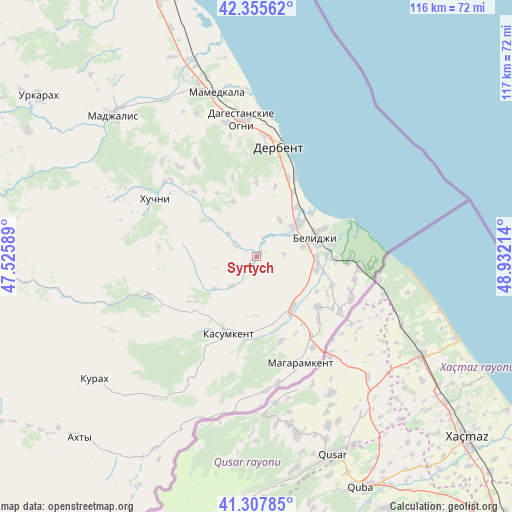
Syrtych GPS coordinates[2]
41° 50' 1.968" North, 48° 13' 44.436" East
| Map corner | latitude | longitude |
|---|---|---|
| Upper-left | 42.35562°, | 47.52589° |
| Center: | 41.83388°, | 48.22901° |
| Lower-right: | 41.30785°, | 48.93214° |
| Map W x H: | 116.5×116.5 km | = 72.4×72.4mi |
| max Lat: | 73.50819° ⇑99.7% North |
| Syrtych: | 41.83388° |
| min Lat: | ⇓0.3% South 41.28413° |
| min Long | Syrtych | max Long |
| -179.12198° | 48.22901° | 179.35046° |
| W 59.4%⇐ | ⇒40.6% E |
Elevation
Elevation of Syrtych is 149 m = 489 ft, and this is 53.6 m = 176 ft below average elevation for this country.
| Max E: |
2518 m = 8261 ft | 48.1% |
| Avg. | 202.6 m = 665 ft | |
| Syrtych | 149 m = 489 ft | |
Min E: |
-28 m = -92 ft | 51.9% |
See also: Russia elevation on elevation.city.
Geographical zone
Syrtych is located in North temperate zone (between Tropic of Cancer and the Arctic Circle). Distance of this Northern Tropic circle is 2045.6 km =1271.1 mi to South.| Distance of | km | miles | from Syrtych |
|---|---|---|---|
| North Pole | 5355.6 | 3327.8 | to North |
| Arctic Circle | 2749.7 | 1708.6 | to North |
| Tropic Cancer | 2045.6 | 1271.1 | to South |
| Equator | 4651.5 | 2890.3 | to South |


Nearby cities:
15 places around Syrtych: (largest is in red/bold)
• Belidzhi
16.5 km =10.3 mi,  67°
67°
• Chinar
31.3 km =19.4 mi,  346°
346°
• Dagestanskiye Ogni
31.5 km =19.6 mi, 354°
• Derbent
26.5 km =16.5 mi,  10°
10°
• Gedzhukh
35.4 km =22 mi,  337°
337°
• Gereykhanovskoye
15.4 km =9.6 mi,  163°
163°
• Kasumkent
18.7 km =11.6 mi,  201°
201°
• Khazar
20.1 km =12.5 mi,  25°
25°
• Khiv
26.3 km =16.3 mi,  250°
250°
• Khuchni
26.6 km =16.5 mi,  299°
299°
• Kurkent
16.5 km =10.3 mi,  214°
214°
• Magaramkent
26.2 km =16.3 mi, 157°
• Novaya Maka
13 km =8.1 mi,  122°
122°
• Sabnova
25.6 km =15.9 mi,  4°
4°
• Samur
21.3 km =13.2 mi,  92°
92°
Sources, notices
• [Note1] Compared only with cities in Russia existing in our database
• [Src1] Map data: © OpenStreetMap contributors (CC-BY-SA)
• [Src2] Other city data from geonames.org with taken over terms of usage.
• [Src3] Geographical zone / Annual Mean Temperature by Robert A. Rohde @ Wikipedia
