Khuchni geodata
Khuchni (Dagestan) is a populated place; located in Russia in Europe/Moscow (GMT+3) time zone. With population of 3,637 people, there are 3312 cities with bigger population in this country. Compared to other cities in Russia, 99.6% of cities are located further ↑North; 58.7% of cities are located further ←West and 95% of cities have lower elevation than Khuchni. Note1


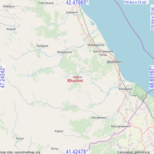
Khuchni GPS coordinates[2]
41° 56' 59.496" North, 47° 56' 54.744" East
| Map corner | latitude | longitude |
|---|---|---|
| Upper-left | 42.47065°, | 47.24542° |
| Center: | 41.94986°, | 47.94854° |
| Lower-right: | 41.42478°, | 48.65167° |
| Map W x H: | 116.3×116.3 km | = 72.3×72.3mi |
| max Lat: | 73.50819° ⇑99.6% North |
| Khuchni: | 41.94986° |
| min Lat: | ⇓0.4% South 41.28413° |
| min Long | Khuchni | max Long |
| -179.12198° | 47.94854° | 179.35046° |
| W 58.7%⇐ | ⇒41.3% E |
Elevation
Elevation of Khuchni is 630 m = 2067 ft, and this is 427.4 m = 1402 ft above average elevation for this country.
| Max E: |
2518 m = 8261 ft | 5% |
| Khuchni | 630 m 2067 ft | |
| Avg. | 202.6 m = 665 ft | |
Min E: |
-28 m = -92 ft | 95% |
See also: Russia elevation on elevation.city.
Geographical zone
Khuchni is located in North temperate zone (between Tropic of Cancer and the Arctic Circle). Distance of this Northern Tropic circle is 2058.5 km =1279.1 mi to South.| Distance of | km | miles | from Khuchni |
|---|---|---|---|
| North Pole | 5342.7 | 3319.8 | to North |
| Arctic Circle | 2736.8 | 1700.6 | to North |
| Tropic Cancer | 2058.5 | 1279.1 | to South |
| Equator | 4664.4 | 2898.3 | to South |


Nearby cities:
15 places around Khuchni: (largest is in red/bold)
• Chinar
23.8 km =14.8 mi,  42°
42°
• Dagestanskiye Ogni
27.3 km =17 mi,  47°
47°
• Derbent
31.1 km =19.3 mi,  65°
65°
• Druzhba
32.8 km =20.4 mi,  7°
7°
• Gedzhukh
22 km =13.7 mi,  25°
25°
• Kasumkent
34.4 km =21.4 mi,  151°
151°
• Khazar
32.2 km =20 mi,  80°
80°
• Khiv
21.8 km =13.5 mi,  183°
183°
• Kubachi
32.3 km =20.1 mi,  297°
297°
• Kurkent
29.8 km =18.5 mi, 152°
• Madzhalis
21.3 km =13.2 mi,  333°
333°
• Mamedkala
27.9 km =17.3 mi, 29°
• Sabnova
28.2 km =17.5 mi,  63°
63°
• Syrtych
26.6 km =16.5 mi,  119°
119°
• Velikent
28.1 km =17.5 mi,  19°
19°
Sources, notices
• [Note1] Compared only with cities in Russia existing in our database
• [Src1] Map data: © OpenStreetMap contributors (CC-BY-SA)
• [Src2] Other city data from geonames.org with taken over terms of usage.
• [Src3] Geographical zone / Annual Mean Temperature by Robert A. Rohde @ Wikipedia
