Chinar geodata
Chinar (Dagestan) is a populated place; located in Russia in Europe/Moscow (GMT+3) time zone. With population of 4,665 people, there are 2799 cities with bigger population in this country. Compared to other cities in Russia, 99.5% of cities are located further ↑North; 59.3% of cities are located further ←West and 81.7% of cities have higher elevation than Chinar. Note1


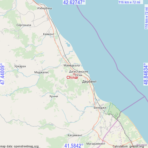
Chinar GPS coordinates[2]
42° 6' 28.728" North, 48° 8' 35.556" East
| Map corner | latitude | longitude |
|---|---|---|
| Upper-left | 42.62747°, | 47.44009° |
| Center: | 42.10798°, | 48.14321° |
| Lower-right: | 41.5842°, | 48.84634° |
| Map W x H: | 116×116 km | = 72.1×72.1mi |
| max Lat: | 73.50819° ⇑99.5% North |
| Chinar: | 42.10798° |
| min Lat: | ⇓0.5% South 41.28413° |
| min Long | Chinar | max Long |
| -179.12198° | 48.14321° | 179.35046° |
| W 59.3%⇐ | ⇒40.7% E |
Elevation
Elevation of Chinar is 65 m = 213 ft, and this is 137.6 m = 451 ft below average elevation for this country.
| Max E: |
2518 m = 8261 ft | 81.7% |
| Avg. | 202.6 m = 665 ft | |
| Chinar | 65 m = 213 ft | |
Min E: |
-28 m = -92 ft | 18.3% |
See also: Russia elevation on elevation.city.
Geographical zone
Chinar is located in North temperate zone (between Tropic of Cancer and the Arctic Circle). Distance of this Northern Tropic circle is 2076 km =1290 mi to South.| Distance of | km | miles | from Chinar |
|---|---|---|---|
| North Pole | 5325.1 | 3308.9 | to North |
| Arctic Circle | 2719.2 | 1689.6 | to North |
| Tropic Cancer | 2076 | 1290 | to South |
| Equator | 4682 | 2909.3 | to South |


Nearby cities:
15 places around Chinar: (largest is in red/bold)
• Belidzhi
32.8 km =20.4 mi,  137°
137°
• Dagestanskiye Ogni
4.1 km =2.5 mi,  77°
77°
• Derbent
12.9 km =8 mi,  110°
110°
• Druzhba
18.9 km =11.7 mi,  321°
321°
• Gedzhukh
6.8 km =4.2 mi,  288°
288°
• Gerga
30.4 km =18.9 mi,  330°
330°
• Kayakent
36.8 km =22.9 mi, 327°
• Khazar
19.9 km =12.4 mi,  128°
128°
• Khuchni
23.8 km =14.8 mi,  222°
222°
• Madzhalis
25.6 km =15.9 mi,  273°
273°
• Mamedkala
7 km =4.3 mi,  341°
341°
• Novokayakent
34.3 km =21.3 mi, 337°
• Sabnova
10.4 km =6.5 mi,  118°
118°
• Syrtych
31.3 km =19.4 mi,  166°
166°
• Velikent
11 km =6.8 mi, 323°
Sources, notices
• [Note1] Compared only with cities in Russia existing in our database
• [Src1] Map data: © OpenStreetMap contributors (CC-BY-SA)
• [Src2] Other city data from geonames.org with taken over terms of usage.
• [Src3] Geographical zone / Annual Mean Temperature by Robert A. Rohde @ Wikipedia
