Khazar geodata
Khazar (Dagestan) is a populated place; located in Russia in Europe/Moscow (GMT+3) time zone. With population of 3,736 people, there are 3243 cities with bigger population in this country. Compared to other cities in Russia, 99.6% of cities are located further ↑North; 59.7% of cities are located further ←West and 99.4% of cities have higher elevation than Khazar. Note1


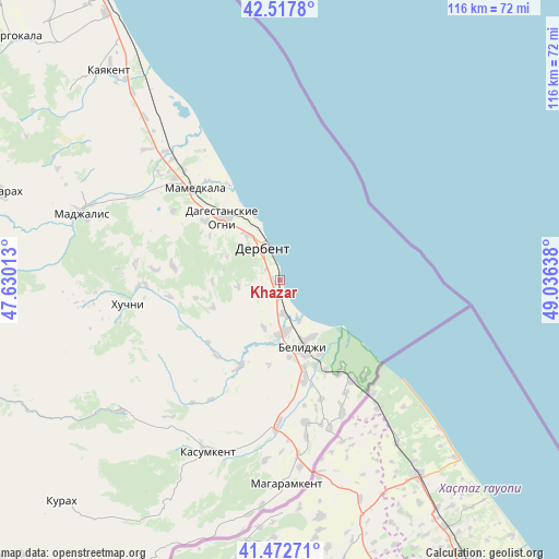
Khazar GPS coordinates[2]
41° 59' 50.64" North, 48° 19' 59.7" East
| Map corner | latitude | longitude |
|---|---|---|
| Upper-left | 42.5178°, | 47.63013° |
| Center: | 41.9974°, | 48.33325° |
| Lower-right: | 41.47271°, | 49.03638° |
| Map W x H: | 116.2×116.2 km | = 72.2×72.2mi |
| max Lat: | 73.50819° ⇑99.6% North |
| Khazar: | 41.9974° |
| min Lat: | ⇓0.4% South 41.28413° |
| min Long | Khazar | max Long |
| -179.12198° | 48.33325° | 179.35046° |
| W 59.7%⇐ | ⇒40.3% E |
Elevation
Elevation of Khazar is -15 m = -49 ft, and this is 217.6 m = 714 ft below average elevation for this country.
| Max E: |
2518 m = 8261 ft | 99.4% |
| Avg. | 202.6 m = 665 ft | |
| Khazar | -15 m = -49 ft | |
Min E: |
-28 m = -92 ft | 0.6% |
See also: Russia elevation on elevation.city.
Geographical zone
Khazar is located in North temperate zone (between Tropic of Cancer and the Arctic Circle). Distance of this Northern Tropic circle is 2063.8 km =1282.4 mi to South.| Distance of | km | miles | from Khazar |
|---|---|---|---|
| North Pole | 5337.4 | 3316.5 | to North |
| Arctic Circle | 2731.5 | 1697.3 | to North |
| Tropic Cancer | 2063.8 | 1282.4 | to South |
| Equator | 4669.7 | 2901.6 | to South |


Nearby cities:
15 places around Khazar: (largest is in red/bold)
• Belidzhi
13.4 km =8.3 mi,  150°
150°
• Chinar
19.9 km =12.4 mi,  308°
308°
• Dagestanskiye Ogni
17.6 km =10.9 mi,  318°
318°
• Derbent
8.6 km =5.3 mi,  335°
335°
• Druzhba
38.6 km =24 mi, 314°
• Gedzhukh
26.5 km =16.5 mi,  303°
303°
• Gereykhanovskoye
33.2 km =20.6 mi,  187°
187°
• Khuchni
32.2 km =20 mi,  260°
260°
• Kurkent
36.5 km =22.7 mi,  209°
209°
• Mamedkala
26 km =16.2 mi, 316°
• Novaya Maka
25.2 km =15.7 mi,  174°
174°
• Sabnova
9.9 km =6.2 mi, 317°
• Samur
22.9 km =14.2 mi, 146°
• Syrtych
20.1 km =12.5 mi, 205°
• Velikent
30.7 km =19.1 mi, 313°
Sources, notices
• [Note1] Compared only with cities in Russia existing in our database
• [Src1] Map data: © OpenStreetMap contributors (CC-BY-SA)
• [Src2] Other city data from geonames.org with taken over terms of usage.
• [Src3] Geographical zone / Annual Mean Temperature by Robert A. Rohde @ Wikipedia
