Syava geodata
Syava (Nizhny Novgorod Oblast) is a populated place; located in Russia in Europe/Moscow (GMT+3) time zone. With population of 3,776 people, there are 3230 cities with bigger population in this country. Compared to other cities in Russia, 82.7% of cities are located further ↓South; 53.6% of cities are located further ←West and 68.2% of cities have higher elevation than Syava. Note1


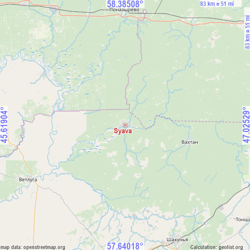
Syava GPS coordinates[2]
58° 0' 52.452" North, 46° 19' 19.776" East
| Map corner | latitude | longitude |
|---|---|---|
| Upper-left | 58.38508°, | 45.61904° |
| Center: | 58.01457°, | 46.32216° |
| Lower-right: | 57.64018°, | 47.02529° |
| Map W x H: | 82.8×82.8 km | = 51.4×51.4mi |
| max Lat: | 73.50819° ⇑17.3% North |
| Syava: | 58.01457° |
| min Lat: | ⇓82.7% South 41.28413° |
| min Long | Syava | max Long |
| -179.12198° | 46.32216° | 179.35046° |
| W 53.6%⇐ | ⇒46.4% E |
Elevation
Elevation of Syava is 107 m = 351 ft, and this is 95.6 m = 314 ft below average elevation for this country.
| Max E: |
2518 m = 8261 ft | 68.2% |
| Avg. | 202.6 m = 665 ft | |
| Syava | 107 m = 351 ft | |
Min E: |
-28 m = -92 ft | 31.8% |
See also: Russia elevation on elevation.city.
Geographical zone
Syava is located in North temperate zone (between Tropic of Cancer and the Arctic Circle). Distance of this North polar circle is 950.6 km =590.7 mi to North.| Distance of | km | miles | from Syava |
|---|---|---|---|
| North Pole | 3556.4 | 2209.8 | to North |
| Arctic Circle | 950.6 | 590.7 | to North |
| Tropic Cancer | 3844.7 | 2389 | to South |
| Equator | 6450.6 | 4008.2 | to South |


Nearby cities:
15 places around Syava: (largest is in red/bold)
• Ar’ya
61.9 km =38.5 mi,  199°
199°
• Leninskoye
56.1 km =34.9 mi,  53°
53°
• Pizhma
49.8 km =30.9 mi,  109°
109°
• Ponazyrevo
38.2 km =23.7 mi,  359°
359°
• Prudy
49.1 km =30.5 mi,  183°
183°
• Shakhun’ya
41.4 km =25.7 mi,  155°
155°
• Shar’ya
61.5 km =38.2 mi,  309°
309°
• Shaygino
42.1 km =26.2 mi,  130°
130°
• Svecha
76 km =47.2 mi,  67°
67°
• Tonkino
71.9 km =44.7 mi,  173°
173°
• Tonshayevo
51.2 km =31.8 mi, 127°
• Uren’
69.9 km =43.4 mi,  207°
207°
• Vakhtan
22.3 km =13.9 mi,  104°
104°
• Vetluga
36.5 km =22.7 mi,  241°
241°
• Vetluzhskiy
65.3 km =40.6 mi, 309°
Sources, notices
• [Note1] Compared only with cities in Russia existing in our database
• [Src1] Map data: © OpenStreetMap contributors (CC-BY-SA)
• [Src2] Other city data from geonames.org with taken over terms of usage.
• [Src3] Geographical zone / Annual Mean Temperature by Robert A. Rohde @ Wikipedia
