Leninskoye geodata
Leninskoye (Kirov) is a populated place; located in Russia in Europe/Kirov (GMT+3) time zone. With population of 5,323 people, there are 2498 cities with bigger population in this country. Compared to other cities in Russia, 84% of cities are located further ↓South; 56.2% of cities are located further ←West and 57.7% of cities have lower elevation than Leninskoye. Note1


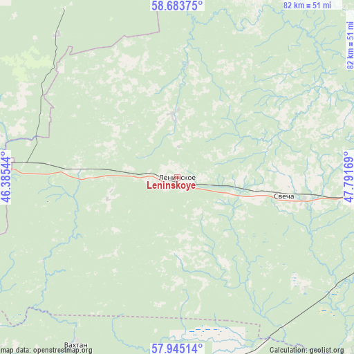
Leninskoye GPS coordinates[2]
58° 18' 58.932" North, 47° 5' 18.816" East
| Map corner | latitude | longitude |
|---|---|---|
| Upper-left | 58.68375°, | 46.38544° |
| Center: | 58.31637°, | 47.08856° |
| Lower-right: | 57.94514°, | 47.79169° |
| Map W x H: | 82.1×82.1 km | = 51×51mi |
| max Lat: | 73.50819° ⇑16% North |
| Leninskoye: | 58.31637° |
| min Lat: | ⇓84% South 41.28413° |
| min Long | Leninskoye | max Long |
| -179.12198° | 47.08856° | 179.35046° |
| W 56.2%⇐ | ⇒43.8% E |
Elevation
Elevation of Leninskoye is 162 m = 531 ft, and this is 40.6 m = 133 ft below average elevation for this country.
| Max E: |
2518 m = 8261 ft | 42.3% |
| Avg. | 202.6 m = 665 ft | |
| Leninskoye | 162 m = 531 ft | |
Min E: |
-28 m = -92 ft | 57.7% |
See also: Russia elevation on elevation.city.
Geographical zone
Leninskoye is located in North temperate zone (between Tropic of Cancer and the Arctic Circle). Distance of this North polar circle is 917 km =569.8 mi to North.| Distance of | km | miles | from Leninskoye |
|---|---|---|---|
| North Pole | 3522.9 | 2189 | to North |
| Arctic Circle | 917 | 569.8 | to North |
| Tropic Cancer | 3878.3 | 2409.9 | to South |
| Equator | 6484.2 | 4029.1 | to South |


Nearby cities:
15 places around Leninskoye: (largest is in red/bold)
• Bogovarovo
73.7 km =45.8 mi,  357°
357°
• Darovskoy
71.3 km =44.3 mi,  44°
44°
• Kotel’nich
73.6 km =45.7 mi,  90°
90°
• Mirnyy
38.4 km =23.9 mi,  59°
59°
• Pizhma
50.3 km =31.3 mi,  178°
178°
• Ponazyrevo
45.4 km =28.2 mi,  275°
275°
• Shakhun’ya
76.6 km =47.6 mi,  201°
201°
• Shar’ya
92 km =57.2 mi,  273°
273°
• Shaygino
62.5 km =38.8 mi,  192°
192°
• Svecha
25.3 km =15.7 mi,  99°
99°
• Syava
56.1 km =34.9 mi,  233°
233°
• Tonshayevo
64.7 km =40.2 mi, 183°
• Vakhtan
45.5 km =28.3 mi,  211°
211°
• Vetluga
92.4 km =57.4 mi,  236°
236°
• Vokhma
70.9 km =44.1 mi,  344°
344°
Sources, notices
• [Note1] Compared only with cities in Russia existing in our database
• [Src1] Map data: © OpenStreetMap contributors (CC-BY-SA)
• [Src2] Other city data from geonames.org with taken over terms of usage.
• [Src3] Geographical zone / Annual Mean Temperature by Robert A. Rohde @ Wikipedia
