Uva geodata
Uva (Udmurtiya Republic) is a populated place; located in Russia in Europe/Samara (GMT+4) time zone. With population of 19,143 people, there are 909 cities with bigger population in this country. Compared to other cities in Russia, 77.2% of cities are located further ↓South; 64.1% of cities are located further ←West and 62% of cities have higher elevation than Uva. Note1


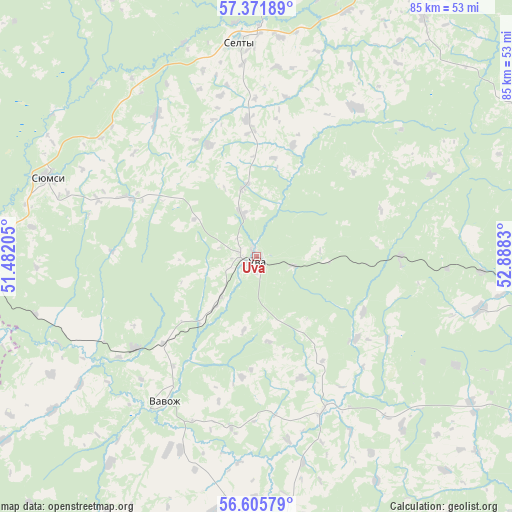
Uva GPS coordinates[2]
56° 59' 26.916" North, 52° 11' 6.612" East
| Map corner | latitude | longitude |
|---|---|---|
| Upper-left | 57.37189°, | 51.48205° |
| Center: | 56.99081°, | 52.18517° |
| Lower-right: | 56.60579°, | 52.8883° |
| Map W x H: | 85.2×85.2 km | = 52.9×52.9mi |
| max Lat: | 73.50819° ⇑22.8% North |
| Uva: | 56.99081° |
| min Lat: | ⇓77.2% South 41.28413° |
| min Long | Uva | max Long |
| -179.12198° | 52.18517° | 179.35046° |
| W 64.1%⇐ | ⇒35.9% E |
Elevation
Elevation of Uva is 120 m = 394 ft, and this is 82.6 m = 271 ft below average elevation for this country.
| Max E: |
2518 m = 8261 ft | 62% |
| Avg. | 202.6 m = 665 ft | |
| Uva | 120 m = 394 ft | |
Min E: |
-28 m = -92 ft | 38% |
See also: Russia elevation on elevation.city.
Geographical zone
Uva is located in North temperate zone (between Tropic of Cancer and the Arctic Circle). Distance of this North polar circle is 1064.4 km =661.4 mi to North.| Distance of | km | miles | from Uva |
|---|---|---|---|
| North Pole | 3670.3 | 2280.6 | to North |
| Arctic Circle | 1064.4 | 661.4 | to North |
| Tropic Cancer | 3730.9 | 2318.3 | to South |
| Equator | 6336.8 | 3937.5 | to South |


Nearby cities:
15 places around Uva: (largest is in red/bold)
• Agryz
71.9 km =44.7 mi,  136°
136°
• Fakel
87.2 km =54.2 mi,  35°
35°
• Igra
81.6 km =50.7 mi, 39°
• Izhevsk
63.8 km =39.6 mi,  104°
104°
• Khokhryaki
69.4 km =43.1 mi, 96°
• Kil’mez’
68.1 km =42.3 mi,  265°
265°
• Kizner
89.7 km =55.7 mi,  207°
207°
• Krasnogorskoye
81.6 km =50.7 mi,  13°
13°
• Malaya Purga
69.4 km =43.1 mi,  134°
134°
• Mozhga
60.8 km =37.8 mi,  177°
177°
• Pirogovo
63.1 km =39.2 mi,  111°
111°
• Pychas
56.4 km =35 mi,  163°
163°
• Selty
36 km =22.4 mi,  355°
355°
• Syumsi
37 km =23 mi,  291°
291°
• Vavozh
28.5 km =17.7 mi, 212°
Sources, notices
• [Note1] Compared only with cities in Russia existing in our database
• [Src1] Map data: © OpenStreetMap contributors (CC-BY-SA)
• [Src2] Other city data from geonames.org with taken over terms of usage.
• [Src3] Geographical zone / Annual Mean Temperature by Robert A. Rohde @ Wikipedia
