Baksanenok geodata
Baksanenok (Kabardino-Balkariya Republic) is a populated place; located in Russia in Europe/Moscow (GMT+3) time zone. With population of 7,058 people, there are 1986 cities with bigger population in this country. Compared to other cities in Russia, 93.1% of cities are located further ↑North; 54% of cities are located further →East and 86.4% of cities have lower elevation than Baksanenok. Note1


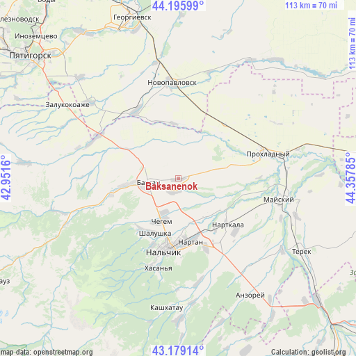
Baksanenok GPS coordinates[2]
43° 41' 22.992" North, 43° 39' 16.992" East
| Map corner | latitude | longitude |
|---|---|---|
| Upper-left | 44.19599°, | 42.9516° |
| Center: | 43.68972°, | 43.65472° |
| Lower-right: | 43.17914°, | 44.35785° |
| Map W x H: | 113.1×113.1 km | = 70.3×70.3mi |
| max Lat: | 73.50819° ⇑93.1% North |
| Baksanenok: | 43.68972° |
| min Lat: | ⇓6.9% South 41.28413° |
| min Long | Baksanenok | max Long |
| -179.12198° | 43.65472° | 179.35046° |
| W 46%⇐ | ⇒54% E |
Elevation
Elevation of Baksanenok is 354 m = 1161 ft, and this is 151.4 m = 497 ft above average elevation for this country.
| Max E: |
2518 m = 8261 ft | 13.6% |
| Baksanenok | 354 m 1161 ft | |
| Avg. | 202.6 m = 665 ft | |
Min E: |
-28 m = -92 ft | 86.4% |
See also: Russia elevation on elevation.city.
Geographical zone
Baksanenok is located in North temperate zone (between Tropic of Cancer and the Arctic Circle). Distance of this Northern Tropic circle is 2251.9 km =1399.3 mi to South.| Distance of | km | miles | from Baksanenok |
|---|---|---|---|
| North Pole | 5149.2 | 3199.6 | to North |
| Arctic Circle | 2543.3 | 1580.3 | to North |
| Tropic Cancer | 2251.9 | 1399.3 | to South |
| Equator | 4857.8 | 3018.5 | to South |


Nearby cities:
15 places around Baksanenok: (largest is in red/bold)
• Altud
17.3 km =10.7 mi,  78°
78°
• Baksan
9.5 km =5.9 mi,  268°
268°
• Chegem Vtoroy
11.3 km =7 mi,  203°
203°
• Dugulubgey
9.9 km =6.2 mi,  252°
252°
• Germenchik
13.9 km =8.6 mi,  139°
139°
• Islamey
16.1 km =10 mi,  264°
264°
• Kamenka
20.6 km =12.8 mi,  212°
212°
• Karagach
16.1 km =10 mi,  36°
36°
• Kishpek
4 km =2.5 mi, 196°
• Kuba-Taba
19.6 km =12.2 mi,  299°
299°
• Kyzburun Pervyy
21.3 km =13.2 mi, 258°
• Nartan
20.2 km =12.6 mi,  169°
169°
• Shalushka
18.9 km =11.7 mi, 202°
• Soldatskaya
19.3 km =12 mi, 42°
• Staropavlovskaya
17.8 km =11.1 mi,  354°
354°
Sources, notices
• [Note1] Compared only with cities in Russia existing in our database
• [Src1] Map data: © OpenStreetMap contributors (CC-BY-SA)
• [Src2] Other city data from geonames.org with taken over terms of usage.
• [Src3] Geographical zone / Annual Mean Temperature by Robert A. Rohde @ Wikipedia
