Matveyev Kurgan geodata
Matveyev Kurgan (Rostov) is a seat of a second-order administrative division; located in Russia in Europe/Moscow (GMT+3) time zone. With population of 14,342 people, there are 1122 cities with bigger population in this country. Compared to other cities in Russia, 81.1% of cities are located further ↑North; 72.9% of cities are located further →East and 90.5% of cities have higher elevation than Matveyev Kurgan. Note1


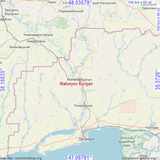
Matveyev Kurgan GPS coordinates[2]
47° 33' 52.2" North, 38° 52' 10.092" East
| Map corner | latitude | longitude |
|---|---|---|
| Upper-left | 48.03679°, | 38.16635° |
| Center: | 47.5645°, | 38.86947° |
| Lower-right: | 47.08791°, | 39.5726° |
| Map W x H: | 105.5×105.5 km | = 65.6×65.6mi |
| max Lat: | 73.50819° ⇑81.1% North |
| Matveyev Kurgan: | 47.5645° |
| min Lat: | ⇓18.9% South 41.28413° |
| min Long | Matveyev Kurgan | max Long |
| -179.12198° | 38.86947° | 179.35046° |
| W 27.1%⇐ | ⇒72.9% E |
Elevation
Elevation of Matveyev Kurgan is 27 m = 89 ft, and this is 175.6 m = 576 ft below average elevation for this country.
| Max E: |
2518 m = 8261 ft | 90.5% |
| Avg. | 202.6 m = 665 ft | |
| Matveyev Kurgan | 27 m = 89 ft | |
Min E: |
-28 m = -92 ft | 9.5% |
See also: Russia elevation on elevation.city.
Geographical zone
Matveyev Kurgan is located in North temperate zone (between Tropic of Cancer and the Arctic Circle). Distance of this North polar circle is 2112.5 km =1312.6 mi to North.| Distance of | km | miles | from Matveyev Kurgan |
|---|---|---|---|
| North Pole | 4718.4 | 2931.9 | to North |
| Arctic Circle | 2112.5 | 1312.6 | to North |
| Tropic Cancer | 2682.8 | 1667 | to South |
| Equator | 5288.7 | 3286.2 | to South |


Nearby cities:
15 places around Matveyev Kurgan: (largest is in red/bold)
• Anastasiyevka
25.6 km =15.9 mi,  269°
269°
• Chaltyr
55.6 km =34.5 mi,  124°
124°
• Kalinin
59.8 km =37.2 mi,  126°
126°
• Krym
56.8 km =35.3 mi, 121°
• Kuybyshevo
27.7 km =17.2 mi,  5°
5°
• Nedvigovka
48.8 km =30.3 mi, 132°
• Novobessergenovka
42.3 km =26.3 mi,  182°
182°
• Persianovka
41.4 km =25.7 mi,  95°
95°
• Pokrovskoye
16.7 km =10.4 mi,  172°
172°
• Primorka
34.5 km =21.4 mi,  154°
154°
• Rodionovo-Nesvetaiskoye
62.4 km =38.8 mi,  86°
86°
• Rodionovo-Nesvetayskaya
63.4 km =39.4 mi, 85°
• Sinyavskoye
44.4 km =27.6 mi,  136°
136°
• Taganrog
36.6 km =22.7 mi, 176°
• Tanais
48 km =29.8 mi, 133°
Sources, notices
• [Note1] Compared only with cities in Russia existing in our database
• [Src1] Map data: © OpenStreetMap contributors (CC-BY-SA)
• [Src2] Other city data from geonames.org with taken over terms of usage.
• [Src3] Geographical zone / Annual Mean Temperature by Robert A. Rohde @ Wikipedia
