Podgorenskiy geodata
Podgorenskiy (Voronezj) is a populated place; located in Russia in Europe/Moscow (GMT+3) time zone. With population of 6,652 people, there are 2087 cities with bigger population in this country. Compared to other cities in Russia, 77% of cities are located further ↑North; 69.4% of cities are located further →East and 69.6% of cities have higher elevation than Podgorenskiy. Note1


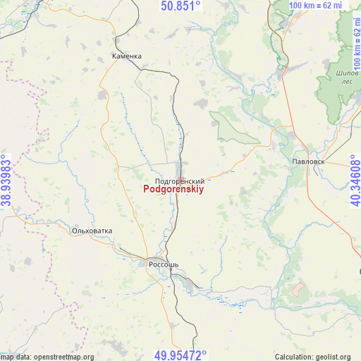
Podgorenskiy GPS coordinates[2]
50° 24' 17.928" North, 39° 38' 34.62" East
| Map corner | latitude | longitude |
|---|---|---|
| Upper-left | 50.851°, | 38.93983° |
| Center: | 50.40498°, | 39.64295° |
| Lower-right: | 49.95472°, | 40.34608° |
| Map W x H: | 99.7×99.7 km | = 62×62mi |
| max Lat: | 73.50819° ⇑77% North |
| Podgorenskiy: | 50.40498° |
| min Lat: | ⇓23% South 41.28413° |
| min Long | Podgorenskiy | max Long |
| -179.12198° | 39.64295° | 179.35046° |
| W 30.6%⇐ | ⇒69.4% E |
Elevation
Elevation of Podgorenskiy is 103 m = 338 ft, and this is 99.6 m = 327 ft below average elevation for this country.
| Max E: |
2518 m = 8261 ft | 69.6% |
| Avg. | 202.6 m = 665 ft | |
| Podgorenskiy | 103 m = 338 ft | |
Min E: |
-28 m = -92 ft | 30.4% |
See also: Russia elevation on elevation.city.
Geographical zone
Podgorenskiy is located in North temperate zone (between Tropic of Cancer and the Arctic Circle). Distance of this North polar circle is 1796.7 km =1116.4 mi to North.| Distance of | km | miles | from Podgorenskiy |
|---|---|---|---|
| North Pole | 4402.6 | 2735.6 | to North |
| Arctic Circle | 1796.7 | 1116.4 | to North |
| Tropic Cancer | 2998.6 | 1863.2 | to South |
| Equator | 5604.5 | 3482.5 | to South |


Nearby cities:
15 places around Podgorenskiy: (largest is in red/bold)
• Belogor’ye
27.6 km =17.1 mi,  69°
69°
• Imeni Pervogo Maya
54 km =33.6 mi,  356°
356°
• Kamenka
37.8 km =23.5 mi,  335°
335°
• Liski
65 km =40.4 mi,  352°
352°
• Losevo
41.5 km =25.8 mi,  43°
43°
• Mitrofanovka
48.4 km =30.1 mi,  175°
175°
• Nizhniy Kislyay
61.9 km =38.5 mi, 37°
• Ol’khovatka
28.7 km =17.8 mi,  241°
241°
• Ostrogozhsk
65.1 km =40.5 mi,  322°
322°
• Pavlovsk
33.5 km =20.8 mi,  79°
79°
• Podgornoye
2.1 km =1.3 mi,  298°
298°
• Rossosh’
23.6 km =14.7 mi,  193°
193°
• Verkhniy Mamon
59.1 km =36.7 mi,  117°
117°
• Vorontsovka
55.4 km =34.4 mi, 65°
• Zabolotovka
27.3 km =17 mi, 238°
Sources, notices
• [Note1] Compared only with cities in Russia existing in our database
• [Src1] Map data: © OpenStreetMap contributors (CC-BY-SA)
• [Src2] Other city data from geonames.org with taken over terms of usage.
• [Src3] Geographical zone / Annual Mean Temperature by Robert A. Rohde @ Wikipedia
