Rossosh’ geodata
Rossosh’ (Voronezj) is a seat of a second-order administrative division; located in Russia in Europe/Moscow (GMT+3) time zone. With population of 62,000 people, there are 333 cities with bigger population in this country. Compared to other cities in Russia, 77.6% of cities are located further ↑North; 69.7% of cities are located further →East and 75.3% of cities have higher elevation than Rossosh’. Note1


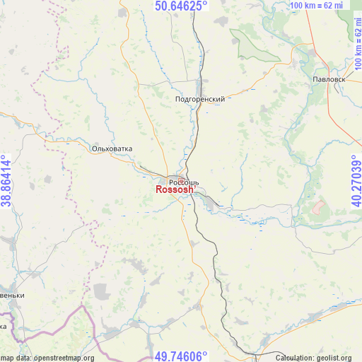
Rossosh’ GPS coordinates[2]
50° 11' 53.808" North, 39° 34' 2.136" East
| Map corner | latitude | longitude |
|---|---|---|
| Upper-left | 50.64625°, | 38.86414° |
| Center: | 50.19828°, | 39.56726° |
| Lower-right: | 49.74606°, | 40.27039° |
| Map W x H: | 100.1×100.1 km | = 62.2×62.2mi |
| max Lat: | 73.50819° ⇑77.6% North |
| Rossosh’: | 50.19828° |
| min Lat: | ⇓22.4% South 41.28413° |
| min Long | Rossosh’ | max Long |
| -179.12198° | 39.56726° | 179.35046° |
| W 30.3%⇐ | ⇒69.7% E |
Elevation
Elevation of Rossosh’ is 87 m = 285 ft, and this is 115.6 m = 379 ft below average elevation for this country.
| Max E: |
2518 m = 8261 ft | 75.3% |
| Avg. | 202.6 m = 665 ft | |
| Rossosh’ | 87 m = 285 ft | |
Min E: |
-28 m = -92 ft | 24.7% |
See also: Rossosh’ elevation on elevation.city.
Geographical zone
Rossosh’ is located in North temperate zone (between Tropic of Cancer and the Arctic Circle). Distance of this North polar circle is 1819.6 km =1130.6 mi to North.| Distance of | km | miles | from Rossosh’ |
|---|---|---|---|
| North Pole | 4425.5 | 2749.9 | to North |
| Arctic Circle | 1819.6 | 1130.6 | to North |
| Tropic Cancer | 2975.6 | 1849 | to South |
| Equator | 5581.5 | 3468.2 | to South |


Nearby cities:
15 places around Rossosh’: (largest is in red/bold)
• Belogor’ye
45.2 km =28.1 mi,  44°
44°
• Boguchar
75.6 km =47 mi,  112°
112°
• Imeni Pervogo Maya
76.9 km =47.8 mi,  1°
1°
• Kamenka
58.4 km =36.3 mi,  349°
349°
• Kantemirovka
58.3 km =36.2 mi,  159°
159°
• Losevo
63 km =39.1 mi,  32°
32°
• Mitrofanovka
26.9 km =16.7 mi, 160°
• Nizhniy Mamon
67 km =41.6 mi,  90°
90°
• Ol’khovatka
22 km =13.7 mi,  295°
295°
• Pavlovsk
48 km =29.8 mi,  53°
53°
• Podgorenskiy
23.6 km =14.7 mi,  13°
13°
• Podgornoye
24.3 km =15.1 mi, 8°
• Verkhniy Mamon
58.2 km =36.2 mi, 93°
• Vorontsovka
72.4 km =45 mi, 50°
• Zabolotovka
20 km =12.4 mi, 296°
Sources, notices
• [Note1] Compared only with cities in Russia existing in our database
• [Src1] Map data: © OpenStreetMap contributors (CC-BY-SA)
• [Src2] Other city data from geonames.org with taken over terms of usage.
• [Src3] Geographical zone / Annual Mean Temperature by Robert A. Rohde @ Wikipedia
