Mitrofanovka geodata
Mitrofanovka (Voronezj) is a populated place; located in Russia in Europe/Moscow (GMT+3) time zone. With population of 5,643 people, there are 2385 cities with bigger population in this country. Compared to other cities in Russia, 78% of cities are located further ↑North; 69.1% of cities are located further →East and 70.4% of cities have lower elevation than Mitrofanovka. Note1


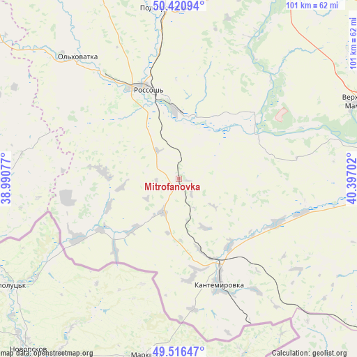
Mitrofanovka GPS coordinates[2]
49° 58' 14.988" North, 39° 41' 38.004" East
| Map corner | latitude | longitude |
|---|---|---|
| Upper-left | 50.42094°, | 38.99077° |
| Center: | 49.97083°, | 39.69389° |
| Lower-right: | 49.51647°, | 40.39702° |
| Map W x H: | 100.6×100.6 km | = 62.5×62.5mi |
| max Lat: | 73.50819° ⇑78% North |
| Mitrofanovka: | 49.97083° |
| min Lat: | ⇓22% South 41.28413° |
| min Long | Mitrofanovka | max Long |
| -179.12198° | 39.69389° | 179.35046° |
| W 30.9%⇐ | ⇒69.1% E |
Elevation
Elevation of Mitrofanovka is 199 m = 653 ft, and this is 3.6 m = 12 ft below average elevation for this country.
| Max E: |
2518 m = 8261 ft | 29.6% |
| Avg. | 202.6 m = 665 ft | |
| Mitrofanovka | 199 m = 653 ft | |
Min E: |
-28 m = -92 ft | 70.4% |
See also: Russia elevation on elevation.city.
Geographical zone
Mitrofanovka is located in North temperate zone (between Tropic of Cancer and the Arctic Circle). Distance of this North polar circle is 1844.9 km =1146.4 mi to North.| Distance of | km | miles | from Mitrofanovka |
|---|---|---|---|
| North Pole | 4450.8 | 2765.6 | to North |
| Arctic Circle | 1844.9 | 1146.4 | to North |
| Tropic Cancer | 2950.3 | 1833.2 | to South |
| Equator | 5556.2 | 3452.5 | to South |


Nearby cities:
15 places around Mitrofanovka: (largest is in red/bold)
• Belogor’ye
62 km =38.5 mi,  21°
21°
• Boguchar
61 km =37.9 mi,  93°
93°
• Chertkovo
72.9 km =45.3 mi,  153°
153°
• Kamenka
85 km =52.8 mi,  346°
346°
• Kantemirovka
31.4 km =19.5 mi,  157°
157°
• Losevo
82.3 km =51.1 mi, 17°
• Nizhniy Mamon
63.2 km =39.3 mi,  66°
66°
• Ol’khovatka
45.2 km =28.1 mi,  320°
320°
• Pavlovsk
61.6 km =38.3 mi,  28°
28°
• Podgorenskiy
48.4 km =30.1 mi,  355°
355°
• Podgornoye
49.6 km =30.8 mi, 353°
• Rossosh’
26.9 km =16.7 mi,  340°
340°
• Verkhniy Mamon
53.7 km =33.4 mi, 66°
• Vorontsovka
85.5 km =53.1 mi, 33°
• Zabolotovka
43.6 km =27.1 mi, 321°
Sources, notices
• [Note1] Compared only with cities in Russia existing in our database
• [Src1] Map data: © OpenStreetMap contributors (CC-BY-SA)
• [Src2] Other city data from geonames.org with taken over terms of usage.
• [Src3] Geographical zone / Annual Mean Temperature by Robert A. Rohde @ Wikipedia
