Belyayevka geodata
Belyayevka (Orenburg Oblast) is a populated place; located in Russia in Asia/Yekaterinburg (GMT+5) time zone. With population of 5,110 people, there are 2604 cities with bigger population in this country. Compared to other cities in Russia, 73.1% of cities are located further ↑North; 68.1% of cities are located further ←West and 58.2% of cities have higher elevation than Belyayevka. Note1


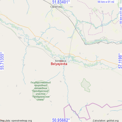
Belyayevka GPS coordinates[2]
51° 23' 50.712" North, 56° 25' 0.012" East
| Map corner | latitude | longitude |
|---|---|---|
| Upper-left | 51.83401°, | 55.71355° |
| Center: | 51.39742°, | 56.41667° |
| Lower-right: | 50.95662°, | 57.1198° |
| Map W x H: | 97.6×97.6 km | = 60.6×60.6mi |
| max Lat: | 73.50819° ⇑73.1% North |
| Belyayevka: | 51.39742° |
| min Lat: | ⇓26.9% South 41.28413° |
| min Long | Belyayevka | max Long |
| -179.12198° | 56.41667° | 179.35046° |
| W 68.1%⇐ | ⇒31.9% E |
Elevation
Elevation of Belyayevka is 128 m = 420 ft, and this is 74.6 m = 245 ft below average elevation for this country.
| Max E: |
2518 m = 8261 ft | 58.2% |
| Avg. | 202.6 m = 665 ft | |
| Belyayevka | 128 m = 420 ft | |
Min E: |
-28 m = -92 ft | 41.8% |
See also: Russia elevation on elevation.city.
Geographical zone
Belyayevka is located in North temperate zone (between Tropic of Cancer and the Arctic Circle). Distance of this North polar circle is 1686.3 km =1047.8 mi to North.| Distance of | km | miles | from Belyayevka |
|---|---|---|---|
| North Pole | 4292.2 | 2667 | to North |
| Arctic Circle | 1686.3 | 1047.8 | to North |
| Tropic Cancer | 3108.9 | 1931.8 | to South |
| Equator | 5714.9 | 3551.1 | to South |


Nearby cities:
15 places around Belyayevka: (largest is in red/bold)
• Dubenskiy
16.3 km =10.1 mi,  67°
67°
• Isyangulovo
88.4 km =54.9 mi,  7°
7°
• Krasnyy Kommunar
96 km =59.7 mi,  311°
311°
• Kuvandyk
65.7 km =40.8 mi,  82°
82°
• Matveyevka
85.2 km =52.9 mi,  349°
349°
• Mednogorsk
81.7 km =50.8 mi,  88°
88°
• Nezhinka
83.2 km =51.7 mi,  299°
299°
• Orenburg
100.2 km =62.3 mi,  294°
294°
• Podgorodnyaya Pokrovka
109.7 km =68.2 mi, 295°
• Prigorodnyy
89.4 km =55.6 mi, 297°
• Sakmara
99.1 km =61.6 mi, 311°
• Saraktash
43.6 km =27.1 mi, 354°
• Sol’-Iletsk
102.5 km =63.7 mi,  255°
255°
• Tatarskaya Kargala
105.5 km =65.6 mi, 305°
• Tyul’gan
106.3 km =66.1 mi, 350°
Sources, notices
• [Note1] Compared only with cities in Russia existing in our database
• [Src1] Map data: © OpenStreetMap contributors (CC-BY-SA)
• [Src2] Other city data from geonames.org with taken over terms of usage.
• [Src3] Geographical zone / Annual Mean Temperature by Robert A. Rohde @ Wikipedia
