Abramovka geodata
Abramovka (Voronezj) is a populated place; located in Russia in Europe/Moscow (GMT+3) time zone. With population of 3,396 people, there are 3469 cities with bigger population in this country. Compared to other cities in Russia, 74% of cities are located further ↑North; 63.1% of cities are located further →East and 53.9% of cities have lower elevation than Abramovka. Note1


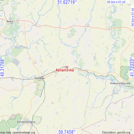
Abramovka GPS coordinates[2]
51° 11' 18.96" North, 41° 1' 12.72" East
| Map corner | latitude | longitude |
|---|---|---|
| Upper-left | 51.62719°, | 40.31708° |
| Center: | 51.1886°, | 41.0202° |
| Lower-right: | 50.7458°, | 41.72333° |
| Map W x H: | 98×98 km | = 60.9×60.9mi |
| max Lat: | 73.50819° ⇑74% North |
| Abramovka: | 51.1886° |
| min Lat: | ⇓26% South 41.28413° |
| min Long | Abramovka | max Long |
| -179.12198° | 41.0202° | 179.35046° |
| W 36.9%⇐ | ⇒63.1% E |
Elevation
Elevation of Abramovka is 154 m = 505 ft, and this is 48.6 m = 159 ft below average elevation for this country.
| Max E: |
2518 m = 8261 ft | 46.1% |
| Avg. | 202.6 m = 665 ft | |
| Abramovka | 154 m = 505 ft | |
Min E: |
-28 m = -92 ft | 53.9% |
See also: Russia elevation on elevation.city.
Geographical zone
Abramovka is located in North temperate zone (between Tropic of Cancer and the Arctic Circle). Distance of this North polar circle is 1709.5 km =1062.2 mi to North.| Distance of | km | miles | from Abramovka |
|---|---|---|---|
| North Pole | 4315.4 | 2681.5 | to North |
| Arctic Circle | 1709.5 | 1062.2 | to North |
| Tropic Cancer | 3085.7 | 1917.4 | to South |
| Equator | 5691.6 | 3536.6 | to South |


Nearby cities:
15 places around Abramovka: (largest is in red/bold)
• Anna
52.6 km =32.7 mi,  308°
308°
• Buturlinovka
49.7 km =30.9 mi,  215°
215°
• Khrenovoye
51.6 km =32.1 mi,  261°
261°
• Kozlovka
53.6 km =33.3 mi,  227°
227°
• Muzhich’ye
49.1 km =30.5 mi,  175°
175°
• Novaya Chigla
38 km =23.6 mi,  275°
275°
• Novokhopërsk
43.4 km =27 mi,  103°
103°
• Sadovoye
52.4 km =32.6 mi,  316°
316°
• Sloboda
50.3 km =31.3 mi, 264°
• Talovaya
21.9 km =13.6 mi,  247°
247°
• Ternovka
69.2 km =43 mi,  38°
38°
• Verkhnyaya Tishanka
37.1 km =23.1 mi,  293°
293°
• Vorob’yëvka
60.3 km =37.5 mi, 184°
• Yelan’-Koleno
15.2 km =9.4 mi,  105°
105°
• Yelan’-Kolenovskiy
9.5 km =5.9 mi, 107°
Sources, notices
• [Note1] Compared only with cities in Russia existing in our database
• [Src1] Map data: © OpenStreetMap contributors (CC-BY-SA)
• [Src2] Other city data from geonames.org with taken over terms of usage.
• [Src3] Geographical zone / Annual Mean Temperature by Robert A. Rohde @ Wikipedia
