Talovaya geodata
Talovaya (Voronezj) is a populated place; located in Russia in Europe/Moscow (GMT+3) time zone. With population of 13,367 people, there are 1177 cities with bigger population in this country. Compared to other cities in Russia, 74.5% of cities are located further ↑North; 64.1% of cities are located further →East and 59.2% of cities have higher elevation than Talovaya. Note1


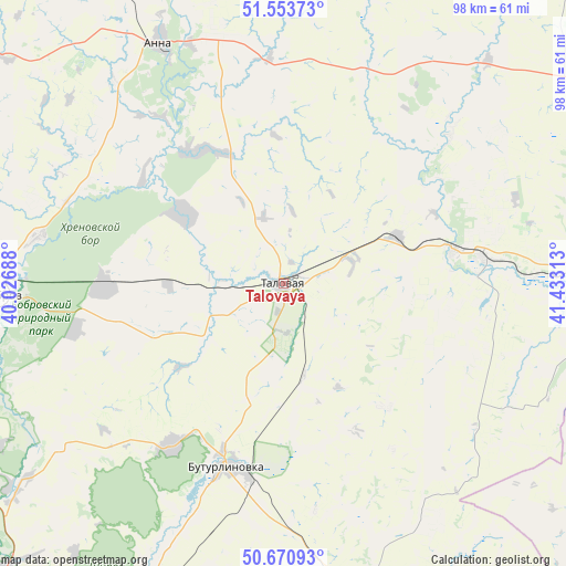
Talovaya GPS coordinates[2]
51° 6' 51.984" North, 40° 43' 48" East
| Map corner | latitude | longitude |
|---|---|---|
| Upper-left | 51.55373°, | 40.02688° |
| Center: | 51.11444°, | 40.73° |
| Lower-right: | 50.67093°, | 41.43313° |
| Map W x H: | 98.2×98.2 km | = 61×61mi |
| max Lat: | 73.50819° ⇑74.5% North |
| Talovaya: | 51.11444° |
| min Lat: | ⇓25.5% South 41.28413° |
| min Long | Talovaya | max Long |
| -179.12198° | 40.73° | 179.35046° |
| W 35.9%⇐ | ⇒64.1% E |
Elevation
Elevation of Talovaya is 126 m = 413 ft, and this is 76.6 m = 251 ft below average elevation for this country.
| Max E: |
2518 m = 8261 ft | 59.2% |
| Avg. | 202.6 m = 665 ft | |
| Talovaya | 126 m = 413 ft | |
Min E: |
-28 m = -92 ft | 40.8% |
See also: Russia elevation on elevation.city.
Geographical zone
Talovaya is located in North temperate zone (between Tropic of Cancer and the Arctic Circle). Distance of this North polar circle is 1717.8 km =1067.4 mi to North.| Distance of | km | miles | from Talovaya |
|---|---|---|---|
| North Pole | 4323.7 | 2686.6 | to North |
| Arctic Circle | 1717.8 | 1067.4 | to North |
| Tropic Cancer | 3077.5 | 1912.3 | to South |
| Equator | 5683.4 | 3531.5 | to South |


Nearby cities:
15 places around Talovaya: (largest is in red/bold)
• Abramovka
21.9 km =13.6 mi,  67°
67°
• Anna
46.1 km =28.6 mi,  333°
333°
• Bobrov
48.7 km =30.3 mi,  267°
267°
• Buturlinovka
33.4 km =20.8 mi,  194°
194°
• Khrenovoye
30.8 km =19.1 mi, 271°
• Kozlovka
34 km =21.1 mi,  214°
214°
• Muzhich’ye
47.2 km =29.3 mi,  149°
149°
• Nizhniy Kislyay
48.9 km =30.4 mi,  233°
233°
• Novaya Chigla
21.3 km =13.2 mi,  304°
304°
• Sadovoye
49 km =30.4 mi,  341°
341°
• Sloboda
30 km =18.6 mi,  275°
275°
• Verkhnyaya Tishanka
27 km =16.8 mi, 329°
• Vorob’yëvka
54.1 km =33.6 mi,  163°
163°
• Yelan’-Koleno
35.2 km =21.9 mi,  83°
83°
• Yelan’-Kolenovskiy
29.9 km =18.6 mi, 79°
Sources, notices
• [Note1] Compared only with cities in Russia existing in our database
• [Src1] Map data: © OpenStreetMap contributors (CC-BY-SA)
• [Src2] Other city data from geonames.org with taken over terms of usage.
• [Src3] Geographical zone / Annual Mean Temperature by Robert A. Rohde @ Wikipedia
