Levashi geodata
Levashi (Dagestan) is a populated place; located in Russia in Europe/Moscow (GMT+3) time zone. With population of 7,817 people, there are 1850 cities with bigger population in this country. Compared to other cities in Russia, 99% of cities are located further ↑North; 57% of cities are located further ←West and 99.1% of cities have lower elevation than Levashi. Note1


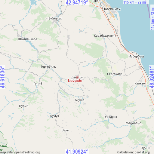
Levashi GPS coordinates[2]
42° 25' 49.296" North, 47° 19' 17.328" East
| Map corner | latitude | longitude |
|---|---|---|
| Upper-left | 42.94719°, | 46.61836° |
| Center: | 42.43036°, | 47.32148° |
| Lower-right: | 41.90924°, | 48.02461° |
| Map W x H: | 115.4×115.4 km | = 71.7×71.7mi |
| max Lat: | 73.50819° ⇑99% North |
| Levashi: | 42.43036° |
| min Lat: | ⇓1% South 41.28413° |
| min Long | Levashi | max Long |
| -179.12198° | 47.32148° | 179.35046° |
| W 57%⇐ | ⇒43% E |
Elevation
Elevation of Levashi is 1234 m = 4049 ft, and this is 1031.4 m = 3384 ft above average elevation for this country.
| Max E: |
2518 m = 8261 ft | 0.90000000000001% |
| Levashi | 1234 m 4049 ft | |
| Avg. | 202.6 m = 665 ft | |
Min E: |
-28 m = -92 ft | 99.1% |
See also: Russia elevation on elevation.city.
Geographical zone
Levashi is located in North temperate zone (between Tropic of Cancer and the Arctic Circle). Distance of this Northern Tropic circle is 2111.9 km =1312.3 mi to South.| Distance of | km | miles | from Levashi |
|---|---|---|---|
| North Pole | 5289.2 | 3286.6 | to North |
| Arctic Circle | 2683.4 | 1667.4 | to North |
| Tropic Cancer | 2111.9 | 1312.3 | to South |
| Equator | 4717.8 | 2931.5 | to South |


Nearby cities:
15 places around Levashi: (largest is in red/bold)
• Akusha
18 km =11.2 mi,  174°
174°
• Dorgeli
26.4 km =16.4 mi,  355°
355°
• Gergebil’
22.5 km =14 mi,  291°
291°
• Gubden
25.2 km =15.7 mi,  52°
52°
• Gunib
29.6 km =18.4 mi,  260°
260°
• Gurbuki
30.5 km =19 mi, 48°
• Karamakhi
21.6 km =13.4 mi,  346°
346°
• Khadzhalmakhi
11.5 km =7.1 mi, 264°
• Mugi
16.7 km =10.4 mi,  150°
150°
• Myurego
30.6 km =19 mi,  94°
94°
• Nizhniy Dzhengutay
30.6 km =19 mi, 348°
• Sergokala
28 km =17.4 mi,  84°
84°
• Ulluaya
7.7 km =4.8 mi, 145°
• Urma
12.4 km =7.7 mi, 346°
• Usisha
20.8 km =12.9 mi,  163°
163°
Sources, notices
• [Note1] Compared only with cities in Russia existing in our database
• [Src1] Map data: © OpenStreetMap contributors (CC-BY-SA)
• [Src2] Other city data from geonames.org with taken over terms of usage.
• [Src3] Geographical zone / Annual Mean Temperature by Robert A. Rohde @ Wikipedia
