Mamedkala geodata
Mamedkala (Dagestan) is a populated place; located in Russia in Europe/Moscow (GMT+3) time zone. With population of 8,965 people, there are 1657 cities with bigger population in this country. Compared to other cities in Russia, 99.4% of cities are located further ↑North; 59.2% of cities are located further ←West and 97.6% of cities have higher elevation than Mamedkala. Note1


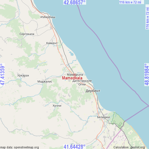
Mamedkala GPS coordinates[2]
42° 10' 3.252" North, 48° 7' 0.156" East
| Map corner | latitude | longitude |
|---|---|---|
| Upper-left | 42.68657°, | 47.41359° |
| Center: | 42.16757°, | 48.11671° |
| Lower-right: | 41.64428°, | 48.81984° |
| Map W x H: | 115.9×115.9 km | = 72×72mi |
| max Lat: | 73.50819° ⇑99.4% North |
| Mamedkala: | 42.16757° |
| min Lat: | ⇓0.6% South 41.28413° |
| min Long | Mamedkala | max Long |
| -179.12198° | 48.11671° | 179.35046° |
| W 59.2%⇐ | ⇒40.8% E |
Elevation
Elevation of Mamedkala is 6 m = 20 ft, and this is 196.6 m = 645 ft below average elevation for this country.
| Max E: |
2518 m = 8261 ft | 97.6% |
| Avg. | 202.6 m = 665 ft | |
| Mamedkala | 6 m = 20 ft | |
Min E: |
-28 m = -92 ft | 2.4% |
See also: Russia elevation on elevation.city.
Geographical zone
Mamedkala is located in North temperate zone (between Tropic of Cancer and the Arctic Circle). Distance of this Northern Tropic circle is 2082.7 km =1294.1 mi to South.| Distance of | km | miles | from Mamedkala |
|---|---|---|---|
| North Pole | 5318.5 | 3304.8 | to North |
| Arctic Circle | 2712.6 | 1685.5 | to North |
| Tropic Cancer | 2082.7 | 1294.1 | to South |
| Equator | 4688.6 | 2913.4 | to South |


Nearby cities:
15 places around Mamedkala: (largest is in red/bold)
• Belidzhi
39.2 km =24.4 mi,  141°
141°
• Chinar
7 km =4.3 mi,  161°
161°
• Dagestanskiye Ogni
8.5 km =5.3 mi,  132°
132°
• Derbent
18.1 km =11.2 mi, 127°
• Druzhba
12.6 km =7.8 mi,  311°
311°
• Gedzhukh
6.2 km =3.9 mi,  224°
224°
• Gerga
23.6 km =14.7 mi,  327°
327°
• Kayakent
30.1 km =18.7 mi,  324°
324°
• Khazar
26 km =16.2 mi, 136°
• Khuchni
27.9 km =17.3 mi,  209°
209°
• Madzhalis
23.9 km =14.9 mi,  257°
257°
• Novokayakent
27.3 km =17 mi,  336°
336°
• Sabnova
16.2 km =10.1 mi, 135°
• Syrtych
38.2 km =23.7 mi,  165°
165°
• Velikent
4.9 km =3 mi,  297°
297°
Sources, notices
• [Note1] Compared only with cities in Russia existing in our database
• [Src1] Map data: © OpenStreetMap contributors (CC-BY-SA)
• [Src2] Other city data from geonames.org with taken over terms of usage.
• [Src3] Geographical zone / Annual Mean Temperature by Robert A. Rohde @ Wikipedia
