Kamennomostskiy geodata
Kamennomostskiy (Adygeya Republic) is a populated place; located in Russia in Europe/Moscow (GMT+3) time zone. With population of 7,585 people, there are 1888 cities with bigger population in this country. Compared to other cities in Russia, 90.2% of cities are located further ↑North; 66.6% of cities are located further →East and 90.1% of cities have lower elevation than Kamennomostskiy. Note1


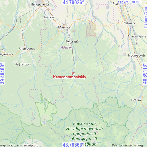
Kamennomostskiy GPS coordinates[2]
44° 17' 20.76" North, 40° 11' 16.8" East
| Map corner | latitude | longitude |
|---|---|---|
| Upper-left | 44.79026°, | 39.48488° |
| Center: | 44.2891°, | 40.188° |
| Lower-right: | 43.78363°, | 40.89113° |
| Map W x H: | 111.9×111.9 km | = 69.5×69.5mi |
| max Lat: | 73.50819° ⇑90.2% North |
| Kamennomostskiy: | 44.2891° |
| min Lat: | ⇓9.8% South 41.28413° |
| min Long | Kamennomostskiy | max Long |
| -179.12198° | 40.188° | 179.35046° |
| W 33.4%⇐ | ⇒66.6% E |
Elevation
Elevation of Kamennomostskiy is 453 m = 1486 ft, and this is 250.4 m = 822 ft above average elevation for this country.
| Max E: |
2518 m = 8261 ft | 9.9% |
| Kamennomostskiy | 453 m 1486 ft | |
| Avg. | 202.6 m = 665 ft | |
Min E: |
-28 m = -92 ft | 90.1% |
See also: Russia elevation on elevation.city.
Geographical zone
Kamennomostskiy is located in North temperate zone (between Tropic of Cancer and the Arctic Circle). Distance of this Northern Tropic circle is 2318.6 km =1440.7 mi to South.| Distance of | km | miles | from Kamennomostskiy |
|---|---|---|---|
| North Pole | 5082.6 | 3158.2 | to North |
| Arctic Circle | 2476.7 | 1538.9 | to North |
| Tropic Cancer | 2318.6 | 1440.7 | to South |
| Equator | 4924.5 | 3059.9 | to South |


Nearby cities:
15 places around Kamennomostskiy: (largest is in red/bold)
• Abadzekhskaya
12 km =7.5 mi,  12°
12°
• Apsheronsk
41 km =25.5 mi,  298°
298°
• Besleneyevskaya
43.2 km =26.8 mi,  98°
98°
• Gubskaya
35.8 km =22.2 mi,  85°
85°
• Khanskaya
46.7 km =29 mi,  337°
337°
• Khodz’
48.5 km =30.1 mi,  59°
59°
• Kuzhorskaya
44 km =27.3 mi, 12°
• Maykop
36 km =22.4 mi,  349°
349°
• Mezmay
20.6 km =12.8 mi,  241°
241°
• Mostovskoy
50.1 km =31.1 mi,  74°
74°
• Neftegorsk
39.1 km =24.3 mi,  282°
282°
• Perepravnaya
47.8 km =29.7 mi,  83°
83°
• Psebay
52.9 km =32.9 mi,  110°
110°
• Tul’skiy
25 km =15.5 mi,  358°
358°
• Yaroslavskaya
41.9 km =26 mi,  31°
31°
Sources, notices
• [Note1] Compared only with cities in Russia existing in our database
• [Src1] Map data: © OpenStreetMap contributors (CC-BY-SA)
• [Src2] Other city data from geonames.org with taken over terms of usage.
• [Src3] Geographical zone / Annual Mean Temperature by Robert A. Rohde @ Wikipedia
