Chegem geodata
Chegem (Kabardino-Balkariya Republic) is a populated place; located in Russia in Europe/Moscow (GMT+3) time zone. With population of 18,429 people, there are 935 cities with bigger population in this country. Compared to other cities in Russia, 95.5% of cities are located further ↑North; 56.2% of cities are located further →East and 100% of cities have lower elevation than Chegem. Note1


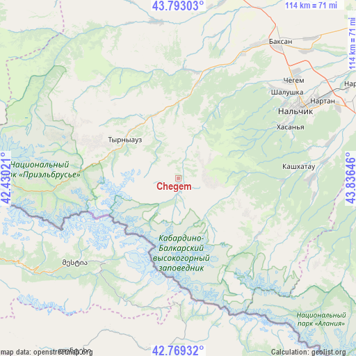
Chegem GPS coordinates[2]
43° 16' 59.988" North, 43° 7' 59.988" East
| Map corner | latitude | longitude |
|---|---|---|
| Upper-left | 43.79303°, | 42.43021° |
| Center: | 43.28333°, | 43.13333° |
| Lower-right: | 42.76932°, | 43.83646° |
| Map W x H: | 113.8×113.8 km | = 70.7×70.7mi |
| max Lat: | 73.50819° ⇑95.5% North |
| Chegem: | 43.28333° |
| min Lat: | ⇓4.5% South 41.28413° |
| min Long | Chegem | max Long |
| -179.12198° | 43.13333° | 179.35046° |
| W 43.8%⇐ | ⇒56.2% E |
Elevation
Elevation of Chegem is 2433 m = 7982 ft, and this is 2230.4 m = 7318 ft above average elevation for this country.
| Max E: |
2518 m = 8261 ft | 0% |
| Chegem | 2433 m 7982 ft | |
| Avg. | 202.6 m = 665 ft | |
Min E: |
-28 m = -92 ft | 100% |
See also: Russia elevation on elevation.city.
Geographical zone
Chegem is located in North temperate zone (between Tropic of Cancer and the Arctic Circle). Distance of this Northern Tropic circle is 2206.7 km =1371.2 mi to South.| Distance of | km | miles | from Chegem |
|---|---|---|---|
| North Pole | 5194.4 | 3227.6 | to North |
| Arctic Circle | 2588.5 | 1608.4 | to North |
| Tropic Cancer | 2206.7 | 1371.2 | to South |
| Equator | 4812.7 | 2990.5 | to South |


Nearby cities:
15 places around Chegem: (largest is in red/bold)
• Babugent
33.7 km =20.9 mi,  90°
90°
• Belaya Rechka
36.7 km =22.8 mi,  62°
62°
• Bylym
21.6 km =13.4 mi,  339°
339°
• El’brus
39.7 km =24.7 mi,  265°
265°
• Gundelen
35.1 km =21.8 mi,  5°
5°
• Kamenka
41.6 km =25.8 mi,  48°
48°
• Kashkhatau
38.6 km =24 mi,  84°
84°
• Kenzhe
42 km =26.1 mi, 54°
• Lashkuta
30.1 km =18.7 mi, 10°
• Lechinkay
39.5 km =24.5 mi,  37°
37°
• Tyrnyauz
20.6 km =12.8 mi,  302°
302°
• Verkhnyaya Balkariya
31.6 km =19.6 mi,  123°
123°
• Zayukovo
40.4 km =25.1 mi,  23°
23°
• Zhankhoteko
31.8 km =19.8 mi, 11°
• Zhemtala
42.3 km =26.3 mi, 89°
Sources, notices
• [Note1] Compared only with cities in Russia existing in our database
• [Src1] Map data: © OpenStreetMap contributors (CC-BY-SA)
• [Src2] Other city data from geonames.org with taken over terms of usage.
• [Src3] Geographical zone / Annual Mean Temperature by Robert A. Rohde @ Wikipedia
