Bylym geodata
Bylym (Kabardino-Balkariya Republic) is a populated place; located in Russia in Europe/Moscow (GMT+3) time zone. With population of 2,064 people, there are 4123 cities with bigger population in this country. Compared to other cities in Russia, 94.3% of cities are located further ↑North; 56.7% of cities are located further →East and 98.7% of cities have lower elevation than Bylym. Note1


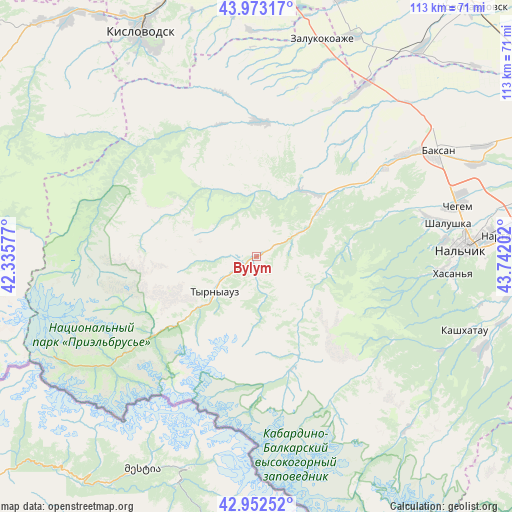
Bylym GPS coordinates[2]
43° 27' 54" North, 43° 2' 20.004" East
| Map corner | latitude | longitude |
|---|---|---|
| Upper-left | 43.97317°, | 42.33577° |
| Center: | 43.465°, | 43.03889° |
| Lower-right: | 42.95252°, | 43.74202° |
| Map W x H: | 113.5×113.5 km | = 70.5×70.5mi |
| max Lat: | 73.50819° ⇑94.3% North |
| Bylym: | 43.465° |
| min Lat: | ⇓5.7% South 41.28413° |
| min Long | Bylym | max Long |
| -179.12198° | 43.03889° | 179.35046° |
| W 43.3%⇐ | ⇒56.7% E |
Elevation
Elevation of Bylym is 1048 m = 3438 ft, and this is 845.4 m = 2774 ft above average elevation for this country.
| Max E: |
2518 m = 8261 ft | 1.3% |
| Bylym | 1048 m 3438 ft | |
| Avg. | 202.6 m = 665 ft | |
Min E: |
-28 m = -92 ft | 98.7% |
See also: Russia elevation on elevation.city.
Geographical zone
Bylym is located in North temperate zone (between Tropic of Cancer and the Arctic Circle). Distance of this Northern Tropic circle is 2226.9 km =1383.7 mi to South.| Distance of | km | miles | from Bylym |
|---|---|---|---|
| North Pole | 5174.2 | 3215.1 | to North |
| Arctic Circle | 2568.3 | 1595.9 | to North |
| Tropic Cancer | 2226.9 | 1383.7 | to South |
| Equator | 4832.9 | 3003 | to South |


Nearby cities:
15 places around Bylym: (largest is in red/bold)
• Belaya Rechka
40.2 km =25 mi,  94°
94°
• Chegem
21.6 km =13.4 mi,  159°
159°
• El’brus
39.4 km =24.5 mi,  234°
234°
• Gundelen
18.2 km =11.3 mi,  36°
36°
• Kamenka
39.3 km =24.4 mi,  78°
78°
• Kamennomostskoye
30.3 km =18.8 mi,  1°
1°
• Kyzburun Pervyy
35.4 km =22 mi,  54°
54°
• Lashkuta
16.1 km =10 mi, 53°
• Lechinkay
33.6 km =20.9 mi,  70°
70°
• Nizhniy Kurkuzhin
40.2 km =25 mi, 38°
• Sarmakovo
33.8 km =21 mi,  22°
22°
• Tyrnyauz
13.4 km =8.3 mi, 226°
• Verkhniy Kurkuzhin
31.9 km =19.8 mi, 36°
• Zayukovo
29.1 km =18.1 mi, 54°
• Zhankhoteko
17.7 km =11 mi, 51°
Sources, notices
• [Note1] Compared only with cities in Russia existing in our database
• [Src1] Map data: © OpenStreetMap contributors (CC-BY-SA)
• [Src2] Other city data from geonames.org with taken over terms of usage.
• [Src3] Geographical zone / Annual Mean Temperature by Robert A. Rohde @ Wikipedia
